Angeles Forest Fires Waterman/Baldy

Tom Moriarty

New member
Could end up being a really bad year for Waterman coming up. With the Angeles National Forest on fire and the possible upcoming El Nino, combining the burned off hillsides along the Angeles Crest Hwy. and the heavy wet rains could lead to a lot of slides and road problems this coming winter. Be interesting to see how this all plays out with the fire though. It is burning from Pasadena to Acton.
 
I've had a good view of the fire's expansion while driving from Glendale to Pasadena, plus a couple of drives up to the Crescenta Valley for a closer view. A few of Samantha's walks have been into affected areas; we'll check those out later in the year when it's cooler.
 
The Station fire is nowhere near Baldy right now. It could theoretically spread East to threaten Waterman, but it's a long way away from that too, and the front seems to be moving mostly North, not East right now. As mentioned in another post, mudslides that threaten Highway 2 are more of a concern to Waterman right now than the actual fire is.

Right now I'm most concerned with some of my favorite hikes in the front range- Switzer Falls/Bear Canyon, Strawberry Peak, San Gabriel Peak, Millard Canyon, etc. These are all most definitely well within the area of the fire. We'll see how things pan out. :-(
 
from today.. looking west towards Waterman...

Station3.jpg
 
Unfortunately, I think it is "highly likely" that this fire will reach Mt. Waterman and Kratka Ridge. At the rate of advance and with no favorable weather in sight it's only a matter of a couple of days at most until it will spread that far. A creek isn't going to stop this fire. This fire grew from 20,000 acres to 42,500 in 24 hours and it is clearly heading in the direction of the ski areas. Keep in mind that growth was without any significant winds. The fire fighting efforts are being focused on the homes and preventing the fire from entering the populated areas. They're already predicting that under a best case scenario this fire won't be contained until September 8 at the earliest.

I certainly hope that it won't reach Mt. Waterman, but I think the likelihood is very high and we should all be very concerned. We saw what happened to Ski Green Valley.
 
Smoke from those fires actually reached SLC yesterday -- the haze in the Valley was amazing.
 
Mt. Waterman / Kratka Ridge is an even bigger concern this morning...

"The station fire doubled in size to 85,000 acres overnight and destroyed more structures."


I'm sorry to say, but by my estimates, based on what I've seen so far the fire will reach the ski area by tomorrow morning.
 
http://www.enplan.com/fires/

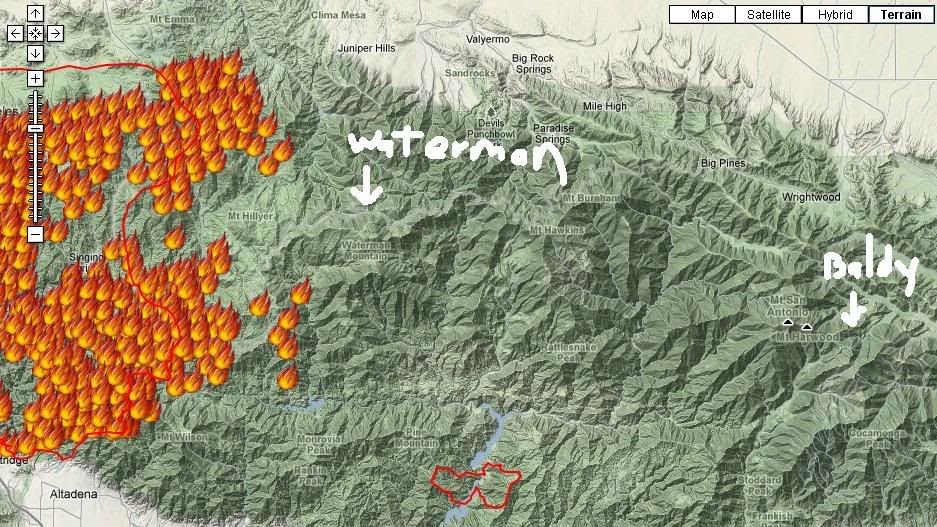
This looks like a good map to follow the Station Fire progress. If you go directly south from the label "Juniper Hills" on the map, Mt. Waterman is about where you hit Angeles Crest Hwy #2. They are definitely defending Mt. Wilson because of the extensive radio/TV and observatory facilities there. But the fire is moving east on the highway north of Mt. Wilson.

The San Gabriel Mts in the current burn area top out at about 6,000 feet. Mt. Waterman is the first peak moving east where altitude jumps up to 8,000, no doubt the reason the ski area was built there. Not sure whether that makes any difference in trying to keep the fire out of the higher mountains.

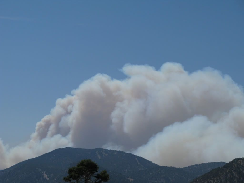
There has been very little wind with this fire; it's just been very hot, 100F+ with ~10% humidity since last Thursday. Today is the first day that the smoke is widespread over the L.A. Basin. Mostly it's hung above the fire or drifted west over the San Fernando Valley some.

With regard to mudslide road closures I recall lengthy closures during the very wet 1977-78 season. There was no access to Mt. Waterman at all for ~6 weeks after a mid-February mudslide. When I finally got up there on April 8, the direct access from La Canada was still blocked; I had to get there via the Little Tujunga road above Sunland. Those same February storms impeded access to the San Bernardino resorts. The road between Big Bear and Snow Valley was down for a few weeks, and when I went to Snow Valley in March I had to use route 18 to Crestline rather than the more direct 330 to Running Springs which was also blocked.

Mt. Baldy is quite a distance from this fire, closer to the much smaller Morris fire which is mostly contained now. A few years back a summer brush fire did get up the backside of Thunder Mt. but did not damage any facilities. In March 1985 the lodge at Baldy Notch burned and had to be rebuilt.
 
Colorado's hazy skies courtesy of California wildfires
http://www.denverpost.com/ci_13240245

It's smokey/thick enough here all of a sudden that I suspect there won't even be a pretty red sunset from it. Good thing I hadn't planned to exercise after work today - it just can't be very good for your lungs.
 
[Updated at 1:50 p.m.: Sixty-five firefighters withdrew from Chilao Flats near the Chilao ranger station. "The intensity of the fire was too strong," said L.A. County Fire Capt. Henry Rodriguez. "They were pulled off the lines and drove away in their vehicles. They're safe and all OK." ]

The depression is starting to set in... so many good years! Thank God I made the trip up there just a couple weeks ago... I think am going for a long walk to cry this out! :(

PS: Rick Metcalf has asked us to all pray for Mt Waterman...
 
Yep, heard the fire chief for the Station Fire say on the news that "It is not presently containable at all, simply defending property is what they can do at times." He stated that the fire fighting efforts are not effective, at all due to conditions of extended heat and years and years of growth." It is so sad when you are a skier it hits home hard. Got off work and drove by the Angeles Crest Hwy the day the fire began to find closed signs due to brush fire. I knew it was not a brush fire, multi-forest fire is more like it. Sometimes we are powerless to fight the fury.................sad. So glad that no ski areas have burned yet. There is always hope, I suppose, but, it looks really bad as it stands today. Perhaps federal monies or something will lead to new high speed chairlifts if the resorts burn down (Waterman/Baldy, but, that is stretching it a lot in bankrupt CA with closing National & State Parks due to budget). :-s
 
Should be an interesting couple of days. That enplan map now showing the fire in Devil's Canyon, putting it much closer to Waterman than before. And if they're evacuating Chilao, that's no bueno.

We need cool, humid weather like, yesterday.

The size of this thing is just absolutely incredible.
 
http://www.inciweb.org/state/5/

Crocker's link is more descriptive. According to the site above, updated 1 minute ago, 1,000 acres have now burned in the San Bernardino Forest, which Mt. Baldy is in. This whole situation is very bad. Hope something good one day will come of it. At least less fuel to burn, at the very least for another 40 years. Donations in all the local ski shops for building new chair lifts, high speed ones, if it burns down, website donations, ???? Something to help, if the worst happens? Hope they are spared, our ski areas!
 
I'm not familiar with the topography... exactly how close is the fire to Waterman or Baldy?

Euh, do they carry fire insurance? 8-[
 
it's getting scary close. i couldnt give you a number but, i would estimate, that if the fire continues at rate, it would reach waterman by tomorrow or wednesday at the latest. how about some san fran fog and cooling. all we can do now is pray. [-o<
 
CW! Baldy is in the Angeles not San Bernardino National Forest.

I got a second hand Forest Service report saying if the fire keeps up at current rate it could be in Wrightwood by Sunday. I sure hope that is just an over exageration.
 
It's still Monday. There are worst-case scenarios with every wildfire that don't occur. (A little optimism for you all).

That San Bernardino County fire is near Yucaipa -- nowhere near Baldy. Station fire is closer.
 
Back
Top