I hadn't been all the way up Angeles Crest Hwy since it reopened in May after repairing the 2005 storm damage. I also thought it would be better for Samantha up there as she doesn't like the heat. Samantha turned 13 on June 24, and the climbing power in her hind legs has declined quite a bit since her last big hikes above Glendale and Pasadena in December/January. She's fine on level ground or gradual inclines for quite a while. So I drove to the Dawson Saddle high point of the road at 7,901 feet. We arrived 9:15 and climbed up to the Pacific Crest trail. I missed the immediate cutoff trail to Throop Peak, so we wound up taking a trace trail up its SW side. Weather was what I wanted, mostly shaded on the north side trail, with a sea breeze once we were on the Pacific Crest. I'd guess 5 miles roundtrip with 1,200 foot gain.
Summit plaque

Views in all directions. SW here, Mt. Wilson (5,700) is the flat mountain just to the left of the smaller tree at right.

W to Mt. Waterman, a couple of the wider runs possibly visible.

Close-by Mt. Baden-Powell to the East. The direct trail there is 2x as much vertical, so I didn't want to stress Samantha on that.

SE to Baldy

South view over L.A. metro. Larger peak sticking out of the haze is Saddleback, highest point in Orange County, a bit over 5,000. The more distant peak at left is probably between Temecula and Camp Pendleton in San Diego County.

We encountered absolutely no one on the entire hike up, but maybe 15-20 people headed up after 11AM while we were on the way down. Coming down the hill Samantha was dragging a bit, probably due to that trace trail at the top. When I stop to give her water she hunts for shade. Desert view to north behind her.

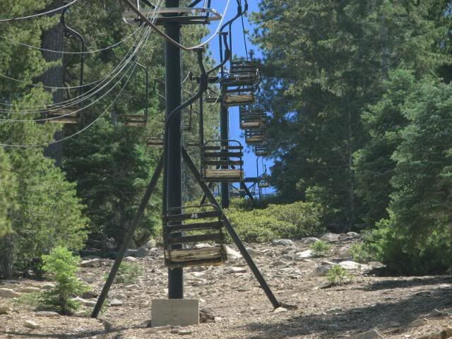
Driving back, here's the defunct single chair at Kratka Ridge (only ski-related content :wink: ).

FYI they were doing scenic rides at Waterman when I passed by around noon.
Summit plaque
Views in all directions. SW here, Mt. Wilson (5,700) is the flat mountain just to the left of the smaller tree at right.
W to Mt. Waterman, a couple of the wider runs possibly visible.
Close-by Mt. Baden-Powell to the East. The direct trail there is 2x as much vertical, so I didn't want to stress Samantha on that.
SE to Baldy
South view over L.A. metro. Larger peak sticking out of the haze is Saddleback, highest point in Orange County, a bit over 5,000. The more distant peak at left is probably between Temecula and Camp Pendleton in San Diego County.
We encountered absolutely no one on the entire hike up, but maybe 15-20 people headed up after 11AM while we were on the way down. Coming down the hill Samantha was dragging a bit, probably due to that trace trail at the top. When I stop to give her water she hunts for shade. Desert view to north behind her.
Driving back, here's the defunct single chair at Kratka Ridge (only ski-related content :wink: ).
FYI they were doing scenic rides at Waterman when I passed by around noon.