You are using an out of date browser. It may not display this or other websites correctly.
You should upgrade or use an alternative browser.
You should upgrade or use an alternative browser.
18-36" in the Utah forecast
- Thread starter Admin
- Start date
 / \
/ \n1vek":2yyn68f7 said:Yeah it looks great. How much terrain would a storm like this open up? I would think a lot, but I don't know much about out there.
It depends on where. On bare ground the storm wouldn't do much, but Alta has a 28-inch base right now, so it'll open a ton (Alta opened most of the mountain last year on opening day on something like a 36-inch base -- it was ugly, but do-able). Snowbird is a much rockier mountain so it requires more snow in some of the nastier spots. Brighton and Solitude will benefit immensely from a storm of this size.
Park City areas will get less, but require less as they're not terribly rocky in most parts of the ski areas. The storm will favor a southern track if the models are correct, so places like Snowbasin and Powder Mountain will get less than ski areas nearer to SLC. If it didn't have such low elevation I'd probably aim for Sundance on Saturday, but the early phases of the storm will be warm and wet with a high snow line. Brian Head ought to get positively pummeled (Flood Watches are posted around St. George).
Almost as important as this storm, however, is the lineup of successive systems on tap for next week, if the forecast holds.
It's ironic because you're in East Lansing, but my best bud's brother is out visiting from Detroit for 10 days. I warned him when he planned this trip that anything is possible this early in the season (I didn't know how right I was!), but things should improve markedly while he's here.
It just keeps getting better -- NOAA Weather Radio out of SLC, which you can listen to online at our Utah-specific site at http://www.utahskiandsnowboard.com/inde ... lay&pid=10 is now forecasting 36" at 9,000 feet along the Wasatch Front!
It's about time. We were starting to think that Admin was boycotting his own forum.
I was at the Alta Peruvian during Christmas week of a lean December. Alta's layout enabled about 75% of terrain to be in decent shape on the reported 47 inch settled base.
Snowbird on the other hand was a minefield. Little Cloud was OK, but it was hard to get down to the base without trashing your skis. Reported base was 37 inches, and I've heard from locals to stay away until it hits 50. Under these conditions Brighton skis similar to Alta and Solitude similar to Snowbird.
I would avoid the Park City group in a slow starting season for quite awhile unless you're mainly interested in skiing groomers.
I would also be skeptical of how fast things will open up this weekend. There will be numerous hidden rocks, and snow stability is not good when you put a big dump on top of a thin base after the prolonged drought. Thus I would expect a cautious attitude from ski patrols in determining safety. My guess is that major expansion of terrain in the Cottonwoods will not happen until Sunday at the earliest.
mbaydala
New member
I was up at Alta today with two friend who I might add are incredible skiers. They were doing front flips off 15 foot cliffs somewhere between spring valley and mambo. I'm running out so I don't have time to post their pictures just yet I was thinking I'd do it once this storm clears.
Anyway I woke up in Park City at 7000 ft to about 10 inches of wet snow, now at 8:30 pm Friday night I have about 16 in my backyard and its coming down at a very good clip.
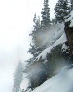
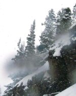
Alta this morning had about 10 inches of a slightly lighter density snow. First runs of the day were spent in the Wildcat area, where I did some damage to my skies on the first couple of runs. Nothing major but enough so that I'll probably want to get another tune in before the new year. Although it was snowing on and off for most of the day it only looked like they picked up about 4 -5 inches at best by the time we left which was about 3 pm. Things got bumped up by the end of the day but the good thing was you could easily located rocks and shrubs that you wanted to avoid.
What is everyone thinking tomorrow. Alta is going to be a complete ZOO!
Anyway I woke up in Park City at 7000 ft to about 10 inches of wet snow, now at 8:30 pm Friday night I have about 16 in my backyard and its coming down at a very good clip.
Alta this morning had about 10 inches of a slightly lighter density snow. First runs of the day were spent in the Wildcat area, where I did some damage to my skies on the first couple of runs. Nothing major but enough so that I'll probably want to get another tune in before the new year. Although it was snowing on and off for most of the day it only looked like they picked up about 4 -5 inches at best by the time we left which was about 3 pm. Things got bumped up by the end of the day but the good thing was you could easily located rocks and shrubs that you wanted to avoid.
What is everyone thinking tomorrow. Alta is going to be a complete ZOO!
mbaydala
New member
Here are the pictures from today up at Alta. If you look carefully you'll see both George (Yellow/Green) and Kent (Blue) hucking about 20 foot cliffs. George charged while Kent went with the front flip. They both stuck their landings.
Can't wait for tomorrow!
Can't wait for tomorrow!
Attachments
-
 Alta 12 inches 10-7 005 George Cliff jump (in yellow).jpg28.5 KB · Views: 3,676
 -
 Alta 12 inches 10-7 006 Kent cliff front flip (in blue).jpg30.6 KB · Views: 3,667
 -
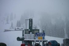 Alta 12 inches 10-7 wildcat 12noon.jpg23.1 KB · Views: 3,676
 -
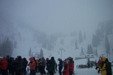 Alta 12 inches 10-7 Waiting for the lifts to open.jpg22.1 KB · Views: 3,675
mbaydala
New member
Just checked the Yard sticks in my backyard in Park City 7000ft. Right now one says 19 inches while the other says 17 inches. The Snowbird cam is off the charts right now!http://www.snowbird.com/snowcam.html
Snow has let up in Park City now probably about .25 inches per hour now.
Snow has let up in Park City now probably about .25 inches per hour now.
What a weekend!
Went up grizzly gulch fri night to camp out in the storm. Fri afternoon's ski tracks had already been covered by 6-8", and i dont remember how many feet of snow into the storm we were already. that night hearing the snow fall on our tents was awesome. Woke up to one of my tent walls sagging in a bit under the weight of the snow piled up. We'd received about 9" more over night. Had bfast, and were lucky enough to hop on the skin track just after a party of 4 breaking trail. We helped out as we caught up to them near the top of fantasy ridge. On the way down the snow was almost too deep. the first run was a lot of pointing them straight and trying to keep moving downhill. On subsequent runs we used our previous troughs to gain speed. Met up with a couple more friends, and we were sharing the skin track with some of the Powder Whores (powderwhore.com). A pic:

More pics here:
http://picasaweb.google.com/evanburgess ... ecember8th
We were skiing mainly southwest facing slopes, and stability was bomber despite a moderate avalanche rating. Sunday, determined to ski steeper terrain where we could enjoy the copious pow, we decided to ski the south face of black knob, near superior. Skinned up to cardiff pass, stability still bomber, but we knew north facing slopes were dangerous and not to be skied. We broke trail from the top of the bowl to the ridge, and didn't quite make the instant mental transition that was needed. We were just a few feet on the north facing side of the ridge, and after about 20ft, we heard a low rumble, then saw a crack form just a few feet down from where we were standing

We got lucky. But we were being stupid. The snowpack is extremely two-faced this year, and when you're changing aspects, the snowpack can entirely change in about 6 feet. We discussed what happened a bit, and decided to get on top of the ridge and stay on it or just south of it on our way out to black knob. turned out that the south facing ridge off black knob had somehow baked already, and the snow was kind of damp. It was also very rocky still. we had some good turns nonetheless, but probably wont ski it again till we get a few more feet.
Went up grizzly gulch fri night to camp out in the storm. Fri afternoon's ski tracks had already been covered by 6-8", and i dont remember how many feet of snow into the storm we were already. that night hearing the snow fall on our tents was awesome. Woke up to one of my tent walls sagging in a bit under the weight of the snow piled up. We'd received about 9" more over night. Had bfast, and were lucky enough to hop on the skin track just after a party of 4 breaking trail. We helped out as we caught up to them near the top of fantasy ridge. On the way down the snow was almost too deep. the first run was a lot of pointing them straight and trying to keep moving downhill. On subsequent runs we used our previous troughs to gain speed. Met up with a couple more friends, and we were sharing the skin track with some of the Powder Whores (powderwhore.com). A pic:
More pics here:
http://picasaweb.google.com/evanburgess ... ecember8th
We were skiing mainly southwest facing slopes, and stability was bomber despite a moderate avalanche rating. Sunday, determined to ski steeper terrain where we could enjoy the copious pow, we decided to ski the south face of black knob, near superior. Skinned up to cardiff pass, stability still bomber, but we knew north facing slopes were dangerous and not to be skied. We broke trail from the top of the bowl to the ridge, and didn't quite make the instant mental transition that was needed. We were just a few feet on the north facing side of the ridge, and after about 20ft, we heard a low rumble, then saw a crack form just a few feet down from where we were standing
We got lucky. But we were being stupid. The snowpack is extremely two-faced this year, and when you're changing aspects, the snowpack can entirely change in about 6 feet. We discussed what happened a bit, and decided to get on top of the ridge and stay on it or just south of it on our way out to black knob. turned out that the south facing ridge off black knob had somehow baked already, and the snow was kind of damp. It was also very rocky still. we had some good turns nonetheless, but probably wont ski it again till we get a few more feet.