Day 8: C...c..c...cold!
(In reality, I should be counting my September skin as it was on new snow and 2,400 verts, so I guess this is really Day 9.)
The Kid and I hooked up with Sam, Dean and Bob Dangerous at 10 am at GMD. I'd only intended to go up for a couple of hours, as the snow is still old and I've got some other things I need to get done. It turned out to be a bit more than that, but not by much.
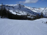
With chilly temps and a stiff southerly wind ahead of our approaching storm system, those first few lift rides were mighty darned nippy! We headed up Collins, but since I hadn't yet been up Supreme this season we headed over there for a couple of runs even though the traverse from Devil's Elbow was closed, so we had to ride Cecret to get there. Discretion and snow conditions dictated that we stick to the groomers, especially after an ill-advised masochistic foray into No. 9 trees. Dumb, dumb, dumb!
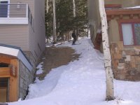
Bob then decided to head to Snowbird, but we opted for the long way around by heading up Sugarloaf, down Mambo and into the trees between Mambo and Main Street (I just can't seem to stick to the groomers!) and up Wildcat, gradually working our way around the shoulder to the west. I wore my Salomon Scream Pilot 10 Hots today, expecting to stick to groomers, and they weren't exactly the plank of choice through the loose sugar in Wildcat. Out past Westward Ho, we descended and kept working our way west until we popped out between two of the mega-mansions newly built on the Blackjack Road.
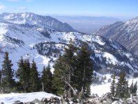
Up the tram and onto the leeward side of of the Cirque onto Silver Fox, where it was stiff chalk -- don't lose an edge here! - down to the Gibraltar Cliffs which are still too bony to ski, so we traversed back over to Chip's. Chip's actually had a lot of loose stuff blown in, and it skied quite well -- the best snow of the weekend, IMO.
Our plan had been for two Tram runs, but I was shot and needed to get home, so we hopped the shuttle back up to Alta and I headed home as The Kid took a couple of more runs with Dean.
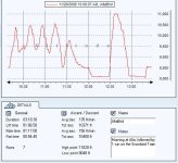
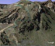
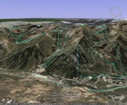
I actually got the GPS track transferred to Google Earth today. This was done with a Pharos mouse GPS unit in a bluetooth sled in a pouch attached to my pack's sternum strap, feeding data wirelessly to a Palm Treo 650 in my pocket to record the data. It was wonderfully geeky to do, but I won't do it regularly. Occasionally it lost sight of the satellites, and as you can see from the image below when it did so it simply drew a straight line between known points. This most prominently happened during our Wildcat foray, where the straight line between the top of Wildcat and our traverse actually places our route on the wrong side of Wildcat Ridge.
Bring on that storm tomorrow!!! [-o<
(In reality, I should be counting my September skin as it was on new snow and 2,400 verts, so I guess this is really Day 9.)
The Kid and I hooked up with Sam, Dean and Bob Dangerous at 10 am at GMD. I'd only intended to go up for a couple of hours, as the snow is still old and I've got some other things I need to get done. It turned out to be a bit more than that, but not by much.
With chilly temps and a stiff southerly wind ahead of our approaching storm system, those first few lift rides were mighty darned nippy! We headed up Collins, but since I hadn't yet been up Supreme this season we headed over there for a couple of runs even though the traverse from Devil's Elbow was closed, so we had to ride Cecret to get there. Discretion and snow conditions dictated that we stick to the groomers, especially after an ill-advised masochistic foray into No. 9 trees. Dumb, dumb, dumb!
Bob then decided to head to Snowbird, but we opted for the long way around by heading up Sugarloaf, down Mambo and into the trees between Mambo and Main Street (I just can't seem to stick to the groomers!) and up Wildcat, gradually working our way around the shoulder to the west. I wore my Salomon Scream Pilot 10 Hots today, expecting to stick to groomers, and they weren't exactly the plank of choice through the loose sugar in Wildcat. Out past Westward Ho, we descended and kept working our way west until we popped out between two of the mega-mansions newly built on the Blackjack Road.
Up the tram and onto the leeward side of of the Cirque onto Silver Fox, where it was stiff chalk -- don't lose an edge here! - down to the Gibraltar Cliffs which are still too bony to ski, so we traversed back over to Chip's. Chip's actually had a lot of loose stuff blown in, and it skied quite well -- the best snow of the weekend, IMO.
Our plan had been for two Tram runs, but I was shot and needed to get home, so we hopped the shuttle back up to Alta and I headed home as The Kid took a couple of more runs with Dean.
I actually got the GPS track transferred to Google Earth today. This was done with a Pharos mouse GPS unit in a bluetooth sled in a pouch attached to my pack's sternum strap, feeding data wirelessly to a Palm Treo 650 in my pocket to record the data. It was wonderfully geeky to do, but I won't do it regularly. Occasionally it lost sight of the satellites, and as you can see from the image below when it did so it simply drew a straight line between known points. This most prominently happened during our Wildcat foray, where the straight line between the top of Wildcat and our traverse actually places our route on the wrong side of Wildcat Ridge.
Bring on that storm tomorrow!!! [-o<
Attachments
-
 04 suunto S6 data altabird 061126.jpg52.9 KB · Views: 1,033
 -
 03 snowbird from hidden peak 061126.jpg112 KB · Views: 1,029
 -
 03 alta getting to snowbird 061126.jpg82.7 KB · Views: 1,015
 -
 02 alta cruising rock n roll 061126.jpg80.7 KB · Views: 1,027
 -
 01 gps track snowbird silver fox 061126.jpg69.1 KB · Views: 1,026
 -
 00 gps track alta snowbird 061126.jpg83 KB · Views: 1,025