tseeb
Well-known member
We stayed in Dillon only 10 miles away from A-Basin. Some of the issues I faced were:
1. A very loving and lovely wife who had enough skiing after 5 days in CO and does not drive in the snow.
2. Checkout at 11 am, no exceptions and my wife had bags to pack.
3. Checked in after 10 pm, too late for a hot tub, too tired for a shower and had not slept very well since first night in CO.
After blogging about previous day at Snowmass and showering, I went out about 7 am and walked around to see how far from highway we were. It was 2 degrees and sunny. We were across from post office. I asked a guy getting into an SUV with ski shop logo on doors about bus to A-Basin and he pointed me towards bus stop across the street. I talked to guy at bus stop that was going to work at Keystone who said you take that bus to Keystone, and then transfer to another bus to Arapahoe. The plan was for my wife to load her stuff at her leisure and then bus to Silverthorne outlets where I would pick her up. I would bus back, but hoped roads would be clear enough that she would pick me up.
It sounded easy enough, but I didn’t think I could make the 811 bus, so I took it easy, loaded all my stuff in the minivan, dressed for skiing and was early for 841 bus. I was joined at the stop by about 15 pre-schoolers and three teachers who were also going to A-basin. The bus was late which meant the 4 minute window for transfer was a problem. The driver told one of the pre-school teachers that A-basin bus would not wait so I got off the bus through the back. I went to plan B which was to think about giving up and then hurriedly pack my wife’s ski and boot bag and large suitcase and everything but her carry-on into the minivan. I drove to A-basin with one ski boot on and one stocking foot and was ready to ski within a minute or two of parking.
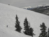
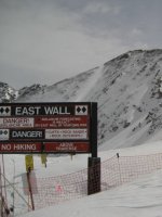
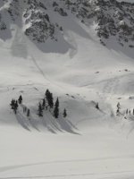
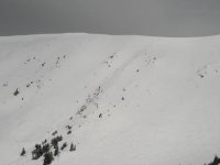
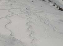
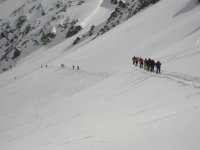
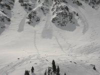
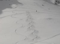
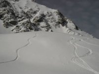
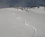
Finally the skiing. I was on Lenawee before 9:30. It was mostly clear with a cold wind from the Montezuma side. I found untracked, very, very lightly wind-crusted on Lenawee Face. Summit county RSN TV said A-basin under-reports and I agree as snow seemed more like 6 inches than 3 inches reported. Next run I skied untracked against the fence on skier’s right of the Face and turned to East Wall gate where I was the third one through. I skied Land of the Giants and then went over a rocky knoll into a narrow gully where I followed two other tracks back to lift. Next time up, somebody had started the traverse to Lower East Wall so I hiked about halfway across where I found untracked nose that had me wondering why people were hiking twice as far. I did that twice and held up under the pressure to leave pretty turns. At least one snowboarder and one skier came rocketing in from far above.
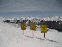
Since I had limited time and wanted to see Montezuma, after 5 rides up Lenawee, I talked to my wife and agreed to pick her up at outlets between 12:30 and 1. I headed skiers left to Mountain Goat traverse where somebody on previous liftride said trees would be great. I took Bierstadt which was so good that I came out 50 feet or so below the chair without realizing it. On the lift up, I saw riders enjoying runs off Zuma Cornice where the snow, which I expected to be wind-blown, looked pretty good. I again went skiers left and cut done earlier through trees to Tieze’s Claim and across Elk Meadows. I still hit all of Torrey’s and had a fine line though the trees, but turned off a little too early due to tired legs and not wanting to repeat sidestep to lift. On the ride up, I realized my cell phone was missing. I must have missed my inside pocket putting it away and thought it must have dropped on walk between tops of Lenawee and Zuma lifts. The Zuma lift operator had it which further made my day.
Since I wanted to see and ski Pallavicini, I skied down the Cornice run and dropped in somewhere between King Cornice and Nose. Even though it was approaching noon and the sun had been hitting the east-facing slopes, the cold temperatures had the lightly-tracked snow still skiing like powder. I found more untracked by keeping left, then cut across bumpy Standard to International. Pali is a scary chair especially with a pack and without a bar as you must be over 150 feet off the ground at one point. I skied between Main Street and East Avenue where I found very steep and untracked lane that reminded me of one of my favorite spots at Sugar Bowl, but this went on three or four times as long. I told myself if I could get down before 12:20, I would take one more. I skied trees on Powder Keg into Scudder and then finished with blasting down mostly groomed Ramrod. I ended up with 11K vertical.
The microphone on my phone was affected by being in the snow so it wasn’t until my wife left me a message with her exact location that I was able to find her at Outlets. After changing and re-packing (and filling up with $3.17 gas), we were on the road at 1:30. We got to airport early enough to have a leisurely lunch, before catching Frontier flight that was arrived San Jose late due to headwinds that kept groundspeed below 400. I returned to 16 year-old with a sore throat and tenants who have mostly moved out (as expected) but still had 20 bags of debris on lawn and mattresses and fridge in front of house.
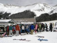
Some quick pictures. I may have better and you really need more than 480 high to show East Wall.
1. A very loving and lovely wife who had enough skiing after 5 days in CO and does not drive in the snow.
2. Checkout at 11 am, no exceptions and my wife had bags to pack.
3. Checked in after 10 pm, too late for a hot tub, too tired for a shower and had not slept very well since first night in CO.
After blogging about previous day at Snowmass and showering, I went out about 7 am and walked around to see how far from highway we were. It was 2 degrees and sunny. We were across from post office. I asked a guy getting into an SUV with ski shop logo on doors about bus to A-Basin and he pointed me towards bus stop across the street. I talked to guy at bus stop that was going to work at Keystone who said you take that bus to Keystone, and then transfer to another bus to Arapahoe. The plan was for my wife to load her stuff at her leisure and then bus to Silverthorne outlets where I would pick her up. I would bus back, but hoped roads would be clear enough that she would pick me up.
It sounded easy enough, but I didn’t think I could make the 811 bus, so I took it easy, loaded all my stuff in the minivan, dressed for skiing and was early for 841 bus. I was joined at the stop by about 15 pre-schoolers and three teachers who were also going to A-basin. The bus was late which meant the 4 minute window for transfer was a problem. The driver told one of the pre-school teachers that A-basin bus would not wait so I got off the bus through the back. I went to plan B which was to think about giving up and then hurriedly pack my wife’s ski and boot bag and large suitcase and everything but her carry-on into the minivan. I drove to A-basin with one ski boot on and one stocking foot and was ready to ski within a minute or two of parking.
Finally the skiing. I was on Lenawee before 9:30. It was mostly clear with a cold wind from the Montezuma side. I found untracked, very, very lightly wind-crusted on Lenawee Face. Summit county RSN TV said A-basin under-reports and I agree as snow seemed more like 6 inches than 3 inches reported. Next run I skied untracked against the fence on skier’s right of the Face and turned to East Wall gate where I was the third one through. I skied Land of the Giants and then went over a rocky knoll into a narrow gully where I followed two other tracks back to lift. Next time up, somebody had started the traverse to Lower East Wall so I hiked about halfway across where I found untracked nose that had me wondering why people were hiking twice as far. I did that twice and held up under the pressure to leave pretty turns. At least one snowboarder and one skier came rocketing in from far above.
Since I had limited time and wanted to see Montezuma, after 5 rides up Lenawee, I talked to my wife and agreed to pick her up at outlets between 12:30 and 1. I headed skiers left to Mountain Goat traverse where somebody on previous liftride said trees would be great. I took Bierstadt which was so good that I came out 50 feet or so below the chair without realizing it. On the lift up, I saw riders enjoying runs off Zuma Cornice where the snow, which I expected to be wind-blown, looked pretty good. I again went skiers left and cut done earlier through trees to Tieze’s Claim and across Elk Meadows. I still hit all of Torrey’s and had a fine line though the trees, but turned off a little too early due to tired legs and not wanting to repeat sidestep to lift. On the ride up, I realized my cell phone was missing. I must have missed my inside pocket putting it away and thought it must have dropped on walk between tops of Lenawee and Zuma lifts. The Zuma lift operator had it which further made my day.
Since I wanted to see and ski Pallavicini, I skied down the Cornice run and dropped in somewhere between King Cornice and Nose. Even though it was approaching noon and the sun had been hitting the east-facing slopes, the cold temperatures had the lightly-tracked snow still skiing like powder. I found more untracked by keeping left, then cut across bumpy Standard to International. Pali is a scary chair especially with a pack and without a bar as you must be over 150 feet off the ground at one point. I skied between Main Street and East Avenue where I found very steep and untracked lane that reminded me of one of my favorite spots at Sugar Bowl, but this went on three or four times as long. I told myself if I could get down before 12:20, I would take one more. I skied trees on Powder Keg into Scudder and then finished with blasting down mostly groomed Ramrod. I ended up with 11K vertical.
The microphone on my phone was affected by being in the snow so it wasn’t until my wife left me a message with her exact location that I was able to find her at Outlets. After changing and re-packing (and filling up with $3.17 gas), we were on the road at 1:30. We got to airport early enough to have a leisurely lunch, before catching Frontier flight that was arrived San Jose late due to headwinds that kept groundspeed below 400. I returned to 16 year-old with a sore throat and tenants who have mostly moved out (as expected) but still had 20 bags of debris on lawn and mattresses and fridge in front of house.
Some quick pictures. I may have better and you really need more than 480 high to show East Wall.
Attachments
-
 3642ZumaSkiersRight.JPG19.7 KB · Views: 2,641
 -
 3639ZumaSigns.JPG31.3 KB · Views: 2,626
 -
 3635EastWallMyTracks.JPG23.2 KB · Views: 2,626
 -
 3634EastWallHike.JPG26.5 KB · Views: 2,622
 -
 3630EastWallEarly.JPG36.3 KB · Views: 2,621
 -
 3626EastWallMyTracks.JPG19.9 KB · Views: 2,620
 -
 3613GiantsEarly.JPG30.7 KB · Views: 2,619
 -
 3609LenaweeFace.JPG21.7 KB · Views: 2,629