J.Spin
New member
A link with additional pictures from the day can be found at the bottom of the report.
James and I had planned to head out for some backcountry skiing in the Bolton Valley area on Sunday, but Lady Luck had a different idea with regard to that plan. Saturday evening I got a call from James and he informed me that he was heading to the emergency room. He had just tweaked his ankle after a chance encounter with some ice in his driveway, and it was serious enough that he was worried there had been a break. Skiing was the last thing James was likely to be doing the next day, except for maybe the combined activity of hiking AND skiing.
The Mt. Mansfield stake had just passed the 40-inch mark on Saturday, which meant that the snowpack in the Northern Green Mountains was entering prime season territory. I definitely didn't want to waste the chance to explore the Bolton backcountry, so I reformulated my plan. I decided to evoke the pass holder's privilege, and do a lift-assisted tour on my own. I wanted to check out something in the Cotton Brook drainage on the back side of the resort. The Bolton Valley Nordic trail map nicely indicated where the Cotton Brook trails were located, so I knew I could take a rather well-traveled route to get there. Using the lift-assisted approach, I knew I wouldn't be able to start my tour until the lifts started running (~9:00 A.M.), but the time and energy saved with the lift ride would make up for the later start.
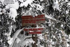
Despite the cold temperatures we've had for the past couple weeks, we've been rather lucky to get mild spells on the weekends. On Saturday, Ty and I had skied in roughly 20-degree weather, but as of Sunday, the temperature was already starting to head south again. It was 8 degrees F when I parked at the base area and headed up the Wilderness Lift. I rode it all the way to the top, and then made my way to the Heavenly Highway. Ahh, the Heavenly Highway; it's probably been 20 years since I last set foot on that trail. Back when I was a youngster, I can remember the joy of climbing the never-ending expanse of Bolton Valley's Nordic terrain on cross-country skis. My friend Sean and I would go up and up and up, as high as we could until we ran out of mountain, or at least until we ran out of trails. I can even remember scooting off onto the Heavenly Highway when we were alpine skiing. Technically, I don't think the resort wanted the alpine skiers on the Nordic trails, but we were kids and we didn't know any better. We just thought it was so neat to ski down the skinny trails. This was an extremely novel thing for us back then. It was the early 80s and it seemed that skiing anywhere off the regular alpine trails was sort of... daffy.
A couple of decades had gone by, but once again I found myself standing at the entrance to the Heavenly Highway. Boy how things had changed. Skiing off the regular trails on big heavy skis didn't seem quite so daffy anymore. In fact, it seemed downright normal. A lot of people were doing it. I pushed off Peggy's Dow and ventured into the depths of the Heavenly Highway, but try as I might, there was no recollecting the nuances of the trail. It was like stepping back into your history with a blindfold. Any detailed memories I had of the area seemed to have evaporated somewhere in my youth. But there was something... something in the back of my mind that knew I'd been in that place before. It's a feeling even more fleeting than déjà vu, but it was there. Perhaps it was the traditional signs of Bolton Valley's network of Nordic trails, or maybe the way the paths worked their way through the high-elevation woods, but something felt awfully familiar. I was back. They say you can never go home again, but maybe "they" weren't skiers.
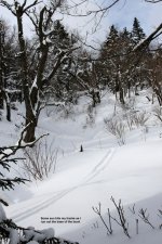
Using my Nordic trail map as a guide, I made my way along the Heavenly Highway and eventually turned onto Paradise Pass. I'd decided not to put on my skins for the trip northward, as it looked like I wasn't going to encounter many serious climbs. Truth be told though, there were a few sections that had climbs of probably up to 50 vertical feet, and they definitely required some side stepping or herring boning. But, I certainly wasn't the first person to follow this route, and plenty of others had used the same technique. If I had to do it again, I'd probably do the same thing, but the one item I'd want to add to my gear would be poles with powder baskets. The biggest problem I encountered was not getting enough push off the snow with my skinny alpine baskets. Eventually, after following Paradise Pass for a bit, I decided it was time to dive into the unknown and make some turns. I had my GPS to show me the topography of the terrain below, but I didn't need it at that point. I just had a gut feeling that the terrain below me was going to be really good... and it was.
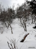
Dropping off Paradise Pass, I immediately came into some fantastic terrain. The pitch quickly rolled over to around 30 degrees, and the trees just opened up. I found myself entering what seemed to be a steep streambed, and although I was initially very cautious with my turns because I was alone, I soon found out that the snow was far too deep to worry much about underlying obstacles. I decided to charge for a few turns and was rewarded with some of the steepest, deepest, sweetest turns of the season so far. The snow was silly deep. If the snow was champagne it probably would have been epic. But, the snow was only medium-weight powder, so it wasn't going to explode up and around my head anytime soon. Oh the horror. Sometimes even in Northern Vermont we have to deal with less than perfect powder. I still couldn't believe what I was skiing. If this line was going to go on for almost 3,000 vertical feet down to the Waterbury Reservoir, there was no way I was going to be able to stop myself; I was probably going to be late getting home for lunch. But unfortunately (or perhaps fortunately) the line didn't continue on forever. After a couple hundred vertical feet, the pitch flattened out and I could see that I was at the bottom of a bowl. I looked around about 180 degrees and could see plenty of glorious lines stretching up above me. One could do laps out there all day. There was one line to the south that I especially liked. What about the snow? Let's just say that at one point I stuck my measurement pole down in the fluff, and although I did pass through one slightly thicker layer, I didn't hit any real base snow until somewhere at the end of my measurement strip - which stops at around 24 inches. The past few weeks of fluff have really added up, especially on the leeward side of Bolton Valley. Coverage on the western side of the mountain is certainly decent, but the eastern side it's even better.
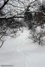
So there I stood at the bottom of the bowl, pretty giddy from the turns. I could see across the big drainage to my southeast, and there were hundreds and hundreds of acres of skiable terrain, and that's just what I could see from that spot. I knew that not everything would have perfectly open lines, but even from such a distance I could see some good ones. The potential out there almost boggles the mind. My cell phone signal was strong, so I snapped a phone picture of the terrain and sent it to E to let her know I was OK (and having quite a bit of fun). I had to make a decision on what to do next. I snapped a few pictures of the beautiful ski lines with my regular camera while I thought about it. There was an old track, possibly of a hiker that passed across the bottom of the bowl, but it didn't give me any help in deciding which way to go. The terrain below seemed to flatten out and get a bit clogged with vegetation, so it felt like I had to go either left or right. It was definitely a bit of a "Two roads diverging in a yellow wood" sort of feeling as I looked as far as I could - until it bent in the undergrowth. I just couldn't get a sense for which direction was going to yield the better turns. It was time for technology. I grabbed my GPS off my shoulder strap and went into map mode to see where the terrain looked best. Even with the topographical map, it was still a hard decision, but I went with the left side because the contour lines looked slightly steeper.
I had to shuffle up a bit of a rise to get moving to the left, but eventually I started down into the next part of the drainage. I was already getting to the stage where I wanted to pick a turnaround point. Since this was a solo outing, and my first time in the area, I didn't want to get too carried away. The vegetation became a bit thicker, but I cautiously skied around in the interest of exploration. I headed generally down and to the left, and finally stopped at an elevation of about 2,650'. I was in an open area of hardwoods, with a much more gradual slope than the bowl I'd encountered above. The terrain immediately below, above, and to the south of me was filled with saplings poking through the snowpack. The terrain was easily skiable, albeit not as aesthetically pleasing as it would be with 2-3 more feet of snow when most of the saplings would disappear. I definitely hadn't found any terrain as great as the first half of my descent, but that's the nature of exploration: sometimes you score, sometimes you strike out, and sometimes you just walk... which is what I decided it was time to do. It did seem like a good spot to end my exploration for the day, so I had a snack, a drink, and put on my skins. I'd forgotten that it was actually a cold day until I noticed the ice crystals forming in my water bottle. I actually enjoy my water with some of those interesting thin frozen plates of ice; it's sort of like an exotic flavorless Slurpee type of drink - until it freezes solid that is. I called E on the phone and let here know that I was starting my ascent. The phone signal was still strong, although the display on my phone was a bit sluggish with the temperature. The sun that had been playing hide and seek up to that point, but it had finally disappeared, and a snow squall came in to change the mood. It was nice to think that the snowpack would only be getting deeper.
Instead of promptly heading back on my downtrack, which wasn't too steep in the immediate area, I started to head a bit further north as I ascended so that I could explore some additional terrain. I quickly found that my downtrack was an excellent route for skinning however, so I returned to it and followed it for a while. Eventually, I broke away from my track as the terrain steepened, and I headed up along the north side of the bowl area, making some switchbacks to accommodate the pitch. For a bit, I followed the old hiker's tracks that I had seen. That person seemed to be post holing in the deep powder and must have had their work cut out for them. Aside from those tracks, I think I may have seen one old ski track in the area, and recreational use seemed to be very meager. I could see that there were a lot of obvious trails in the area, especially at a convergence point near the bottom of the bowl, but none of the trails showed recent use. I didn't see a single person away from the Nordic trails during my tour, which was somewhat surprising; last weekend was one of the best weekends for backcountry skiing so far this season.
As I neared the Nordic trial network again, I heard some people talking, and eventually I found a group of about 5-7 Telemark skiers that were playing around in some small lines near the designated trails. I was surprised that they weren't over in the bowl area, but I think they were on a mellower outing. I was soon back on Paradise Pass, making my way toward the alpine trails. I went to take a drink of my water, but a plug of ice had formed and I couldn't get the water out. Nuts, I suspected that might happen. I decided to wait until I took off my skins before I'd pull out my Swiss army knife to break the ice. I actually did keep my skins on for the return trip across the Nordic trails, which worked out fine. I let the Telemark skiers pass me since my skins kept me a bit slow on the slight downhill sections. I could probably go either way with the skins (on or off) for the out and back trips through the Nordic trails, as there doesn't seem to be a major tendency toward up or down. As I reached the junction with the Heavenly Highway, I found that the crew of Telemark skiers had stopped, and was letting a couple of alpine skiers pass by along the trail. There's really quite an expansive network of Nordic trails out there, and you never know who you're going to meet. I spoke with one of the guys from the Telemark group, and he immediately assumed I'd been skiing out in the bowl area when he saw my alpine skis, so that terrain must be pretty well known.
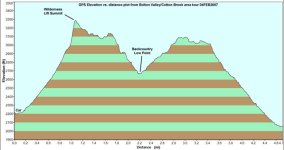
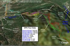
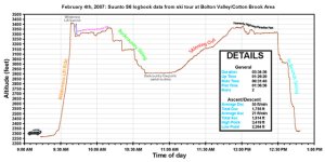
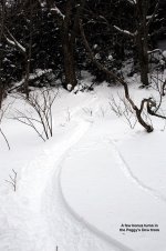
Just before I reach Peggy's Dow, I stopped and took off my skins. I chipped through the ice on my water bottle and was able to take another drink. If I was going on a longer tour, I probably would have wanted to start with some warmer water, or keep my water in a warmer place. I skied down Peggy's Dow, and decided to explore some of the woods off to the skier's right. When I'm out on the slopes with Ty, I don't get to do too much exploring in the woods, so that was a treat. I only hit one open line with good pitch, but I did find some interesting woods that I didn't know about as I worked my way back to the center of the trail network. When I got back to my car, the temperature was somewhere between 10 and 15 degrees F. Those temperatures are a little rougher to handle with wind, so I was happy that the back side of the mountain was so calm. The altimeters both recorded 2 runs for the tour, with the Avocet logging 1,790 vertical feet of descent, and the Suunto logging 1,755 vertical feet of descent for a difference of 2.0%. Last Saturday's 45 inches of snowpack at the Mt. Mansfield stake has already turned into 53 inches after this week's snowfall, and more snow is forecast for tomorrow evening. The backcountry is only getting better with each successive snowfall.
Additional pictures from the day can be found at:
http://www.jandeproductions.com/2007/04FEB07.html
J.Spin
James and I had planned to head out for some backcountry skiing in the Bolton Valley area on Sunday, but Lady Luck had a different idea with regard to that plan. Saturday evening I got a call from James and he informed me that he was heading to the emergency room. He had just tweaked his ankle after a chance encounter with some ice in his driveway, and it was serious enough that he was worried there had been a break. Skiing was the last thing James was likely to be doing the next day, except for maybe the combined activity of hiking AND skiing.
The Mt. Mansfield stake had just passed the 40-inch mark on Saturday, which meant that the snowpack in the Northern Green Mountains was entering prime season territory. I definitely didn't want to waste the chance to explore the Bolton backcountry, so I reformulated my plan. I decided to evoke the pass holder's privilege, and do a lift-assisted tour on my own. I wanted to check out something in the Cotton Brook drainage on the back side of the resort. The Bolton Valley Nordic trail map nicely indicated where the Cotton Brook trails were located, so I knew I could take a rather well-traveled route to get there. Using the lift-assisted approach, I knew I wouldn't be able to start my tour until the lifts started running (~9:00 A.M.), but the time and energy saved with the lift ride would make up for the later start.
Despite the cold temperatures we've had for the past couple weeks, we've been rather lucky to get mild spells on the weekends. On Saturday, Ty and I had skied in roughly 20-degree weather, but as of Sunday, the temperature was already starting to head south again. It was 8 degrees F when I parked at the base area and headed up the Wilderness Lift. I rode it all the way to the top, and then made my way to the Heavenly Highway. Ahh, the Heavenly Highway; it's probably been 20 years since I last set foot on that trail. Back when I was a youngster, I can remember the joy of climbing the never-ending expanse of Bolton Valley's Nordic terrain on cross-country skis. My friend Sean and I would go up and up and up, as high as we could until we ran out of mountain, or at least until we ran out of trails. I can even remember scooting off onto the Heavenly Highway when we were alpine skiing. Technically, I don't think the resort wanted the alpine skiers on the Nordic trails, but we were kids and we didn't know any better. We just thought it was so neat to ski down the skinny trails. This was an extremely novel thing for us back then. It was the early 80s and it seemed that skiing anywhere off the regular alpine trails was sort of... daffy.
A couple of decades had gone by, but once again I found myself standing at the entrance to the Heavenly Highway. Boy how things had changed. Skiing off the regular trails on big heavy skis didn't seem quite so daffy anymore. In fact, it seemed downright normal. A lot of people were doing it. I pushed off Peggy's Dow and ventured into the depths of the Heavenly Highway, but try as I might, there was no recollecting the nuances of the trail. It was like stepping back into your history with a blindfold. Any detailed memories I had of the area seemed to have evaporated somewhere in my youth. But there was something... something in the back of my mind that knew I'd been in that place before. It's a feeling even more fleeting than déjà vu, but it was there. Perhaps it was the traditional signs of Bolton Valley's network of Nordic trails, or maybe the way the paths worked their way through the high-elevation woods, but something felt awfully familiar. I was back. They say you can never go home again, but maybe "they" weren't skiers.
Using my Nordic trail map as a guide, I made my way along the Heavenly Highway and eventually turned onto Paradise Pass. I'd decided not to put on my skins for the trip northward, as it looked like I wasn't going to encounter many serious climbs. Truth be told though, there were a few sections that had climbs of probably up to 50 vertical feet, and they definitely required some side stepping or herring boning. But, I certainly wasn't the first person to follow this route, and plenty of others had used the same technique. If I had to do it again, I'd probably do the same thing, but the one item I'd want to add to my gear would be poles with powder baskets. The biggest problem I encountered was not getting enough push off the snow with my skinny alpine baskets. Eventually, after following Paradise Pass for a bit, I decided it was time to dive into the unknown and make some turns. I had my GPS to show me the topography of the terrain below, but I didn't need it at that point. I just had a gut feeling that the terrain below me was going to be really good... and it was.
Dropping off Paradise Pass, I immediately came into some fantastic terrain. The pitch quickly rolled over to around 30 degrees, and the trees just opened up. I found myself entering what seemed to be a steep streambed, and although I was initially very cautious with my turns because I was alone, I soon found out that the snow was far too deep to worry much about underlying obstacles. I decided to charge for a few turns and was rewarded with some of the steepest, deepest, sweetest turns of the season so far. The snow was silly deep. If the snow was champagne it probably would have been epic. But, the snow was only medium-weight powder, so it wasn't going to explode up and around my head anytime soon. Oh the horror. Sometimes even in Northern Vermont we have to deal with less than perfect powder. I still couldn't believe what I was skiing. If this line was going to go on for almost 3,000 vertical feet down to the Waterbury Reservoir, there was no way I was going to be able to stop myself; I was probably going to be late getting home for lunch. But unfortunately (or perhaps fortunately) the line didn't continue on forever. After a couple hundred vertical feet, the pitch flattened out and I could see that I was at the bottom of a bowl. I looked around about 180 degrees and could see plenty of glorious lines stretching up above me. One could do laps out there all day. There was one line to the south that I especially liked. What about the snow? Let's just say that at one point I stuck my measurement pole down in the fluff, and although I did pass through one slightly thicker layer, I didn't hit any real base snow until somewhere at the end of my measurement strip - which stops at around 24 inches. The past few weeks of fluff have really added up, especially on the leeward side of Bolton Valley. Coverage on the western side of the mountain is certainly decent, but the eastern side it's even better.
So there I stood at the bottom of the bowl, pretty giddy from the turns. I could see across the big drainage to my southeast, and there were hundreds and hundreds of acres of skiable terrain, and that's just what I could see from that spot. I knew that not everything would have perfectly open lines, but even from such a distance I could see some good ones. The potential out there almost boggles the mind. My cell phone signal was strong, so I snapped a phone picture of the terrain and sent it to E to let her know I was OK (and having quite a bit of fun). I had to make a decision on what to do next. I snapped a few pictures of the beautiful ski lines with my regular camera while I thought about it. There was an old track, possibly of a hiker that passed across the bottom of the bowl, but it didn't give me any help in deciding which way to go. The terrain below seemed to flatten out and get a bit clogged with vegetation, so it felt like I had to go either left or right. It was definitely a bit of a "Two roads diverging in a yellow wood" sort of feeling as I looked as far as I could - until it bent in the undergrowth. I just couldn't get a sense for which direction was going to yield the better turns. It was time for technology. I grabbed my GPS off my shoulder strap and went into map mode to see where the terrain looked best. Even with the topographical map, it was still a hard decision, but I went with the left side because the contour lines looked slightly steeper.
I had to shuffle up a bit of a rise to get moving to the left, but eventually I started down into the next part of the drainage. I was already getting to the stage where I wanted to pick a turnaround point. Since this was a solo outing, and my first time in the area, I didn't want to get too carried away. The vegetation became a bit thicker, but I cautiously skied around in the interest of exploration. I headed generally down and to the left, and finally stopped at an elevation of about 2,650'. I was in an open area of hardwoods, with a much more gradual slope than the bowl I'd encountered above. The terrain immediately below, above, and to the south of me was filled with saplings poking through the snowpack. The terrain was easily skiable, albeit not as aesthetically pleasing as it would be with 2-3 more feet of snow when most of the saplings would disappear. I definitely hadn't found any terrain as great as the first half of my descent, but that's the nature of exploration: sometimes you score, sometimes you strike out, and sometimes you just walk... which is what I decided it was time to do. It did seem like a good spot to end my exploration for the day, so I had a snack, a drink, and put on my skins. I'd forgotten that it was actually a cold day until I noticed the ice crystals forming in my water bottle. I actually enjoy my water with some of those interesting thin frozen plates of ice; it's sort of like an exotic flavorless Slurpee type of drink - until it freezes solid that is. I called E on the phone and let here know that I was starting my ascent. The phone signal was still strong, although the display on my phone was a bit sluggish with the temperature. The sun that had been playing hide and seek up to that point, but it had finally disappeared, and a snow squall came in to change the mood. It was nice to think that the snowpack would only be getting deeper.
Instead of promptly heading back on my downtrack, which wasn't too steep in the immediate area, I started to head a bit further north as I ascended so that I could explore some additional terrain. I quickly found that my downtrack was an excellent route for skinning however, so I returned to it and followed it for a while. Eventually, I broke away from my track as the terrain steepened, and I headed up along the north side of the bowl area, making some switchbacks to accommodate the pitch. For a bit, I followed the old hiker's tracks that I had seen. That person seemed to be post holing in the deep powder and must have had their work cut out for them. Aside from those tracks, I think I may have seen one old ski track in the area, and recreational use seemed to be very meager. I could see that there were a lot of obvious trails in the area, especially at a convergence point near the bottom of the bowl, but none of the trails showed recent use. I didn't see a single person away from the Nordic trails during my tour, which was somewhat surprising; last weekend was one of the best weekends for backcountry skiing so far this season.
As I neared the Nordic trial network again, I heard some people talking, and eventually I found a group of about 5-7 Telemark skiers that were playing around in some small lines near the designated trails. I was surprised that they weren't over in the bowl area, but I think they were on a mellower outing. I was soon back on Paradise Pass, making my way toward the alpine trails. I went to take a drink of my water, but a plug of ice had formed and I couldn't get the water out. Nuts, I suspected that might happen. I decided to wait until I took off my skins before I'd pull out my Swiss army knife to break the ice. I actually did keep my skins on for the return trip across the Nordic trails, which worked out fine. I let the Telemark skiers pass me since my skins kept me a bit slow on the slight downhill sections. I could probably go either way with the skins (on or off) for the out and back trips through the Nordic trails, as there doesn't seem to be a major tendency toward up or down. As I reached the junction with the Heavenly Highway, I found that the crew of Telemark skiers had stopped, and was letting a couple of alpine skiers pass by along the trail. There's really quite an expansive network of Nordic trails out there, and you never know who you're going to meet. I spoke with one of the guys from the Telemark group, and he immediately assumed I'd been skiing out in the bowl area when he saw my alpine skis, so that terrain must be pretty well known.
Just before I reach Peggy's Dow, I stopped and took off my skins. I chipped through the ice on my water bottle and was able to take another drink. If I was going on a longer tour, I probably would have wanted to start with some warmer water, or keep my water in a warmer place. I skied down Peggy's Dow, and decided to explore some of the woods off to the skier's right. When I'm out on the slopes with Ty, I don't get to do too much exploring in the woods, so that was a treat. I only hit one open line with good pitch, but I did find some interesting woods that I didn't know about as I worked my way back to the center of the trail network. When I got back to my car, the temperature was somewhere between 10 and 15 degrees F. Those temperatures are a little rougher to handle with wind, so I was happy that the back side of the mountain was so calm. The altimeters both recorded 2 runs for the tour, with the Avocet logging 1,790 vertical feet of descent, and the Suunto logging 1,755 vertical feet of descent for a difference of 2.0%. Last Saturday's 45 inches of snowpack at the Mt. Mansfield stake has already turned into 53 inches after this week's snowfall, and more snow is forecast for tomorrow evening. The backcountry is only getting better with each successive snowfall.
Additional pictures from the day can be found at:
http://www.jandeproductions.com/2007/04FEB07.html
J.Spin