J.Spin
Member
The weather for the Memorial Day weekend was forecast to be quite interesting in western Montana, as well as the rest of the northwestern U.S. The Missoula NWS had winter storm and heavy snow warnings up for almost the entirety of western Montana, with potential snow accumulations of up to 18 inches above 5,000 feet. At our place in Hamilton (elevation 3,590 feet), the temperature dipped down to around 40 degrees F with plenty of rain, and with that temperature in the valley, one wouldn?t have to travel too high into the hills to get into snowfall. As predicted, the incoming weather system contained plenty of moisture; rainfall started on Friday evening, and Saturday was a total washout. Sunday morning picked up right where Saturday left off, with more thick clouds and consistent rain. A day of continuous clouds and rain is already a somewhat rare occurrence for most of the western Montana valleys, but as our recent event continued into Sunday, it became clear that the forecast for a very wet weekend was right on track. It was certainly not the perfect weekend for folks that had made big outdoor holiday plans.
In a total reversal of the previous couple of weekends, I found out from my Dad that in Vermont, they were forecast to have clear skies and temperatures in the low 80s F. Vermont?s Mt. Mansfield had seen about 6 new inches of snow during the previous week, and Mt. Washington in New Hampshire had seen about 18 inches of the white stuff. The fair weather meant that people would at least get a chance to get out and enjoy the new snow. The new snowfall had slowed the progress of finally clearing the snow off the Mt. Washington auto road, but a couple of dry days at the end of the week helped them push through. The road was supposedly opened for tour buses and private vehicles as of Saturday, so it looked like the perfect weekend to head up and enjoy car-serviced access to the summit snowfields (which I?ve heard are in really good shape). I?ve already seen one report of car-served Sunday skiing on the Mt. Washington snowfields over at the First Tracks eastern forum, and it sounded pretty good.
Bruce had approached me earlier in the week about the potential for skiing Trapper Peak, the highest point in the central Bitterroots at 10,157 feet. E and I have hiked Trapper Peak in the summer, but we?ve yet to get up there and ski it. Unfortunately, with a vertical rise of 3,000 to 4,000 feet for the hike, and lower portions that require hiking with skis before one can put on their skins, it?s not a practical ski trip to do while carrying the boys in backpacks. Bruce and I kept the option of skiing Trapper on the side, but with winter storm warnings up and heavy precipitation expected, the Bitterroot alpine just wasn?t a really safe place to visit.
On Sunday morning, Bruce called me and suggested the idea of heading for a tour in the Chief Joseph area. The snow depth at the Saddle Mountain SNOTEL (elevation 7,940 feet) had hit a low of 28.6 inches on May 27th, but now it had peaked at 37.2 inches, suggesting as much 8 or 9 inches of accumulation up there. It was kind of nice in a way, because while the weather was nasty enough to keep us out of the alpine; it was also nasty enough to provide a thick coating of fresh snow below tree line. If you follow the link to the pictures for the report, you?ll find a plot of the snowpack depth for the Saddle Mountain SNOTEL so far this season. The snowpack has been dropping quickly over the past few weeks, but this new storm gave it a small reprieve. The snow accumulation at the SNOTEL gave us hope that there would be enough to ski on at Chief Joseph, and while the temperature of around freezing suggested that it might still be sticking, we?d really have to head up to the pass to get the full story. We weren?t even sure if we?d get to ski at all, but we were optimistic.
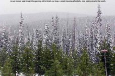
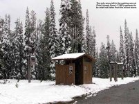
Since we were just going to be skiing relatively flat terrain, I asked E if she wanted to come and bring the boys in the packs. But, Dylan was fighting a bit of a cold so she decided against it. Thus, it would be just Bruce and I. On the drive to the pass, it was raining lightly in the valley, and I saw the first signs of snow along the road at around 4,000 feet, just after we?d passed through Darby. When we arrived at Chief Joseph Pass (elevation 7,280 feet) it was snowing moderately, and we could see that there were about 4-6 inches of new accumulation in the parking lot area. It didn?t look like there was much in the way of old snowpack left, so we probably wouldn?t have been able to do much skiing without the new snow. When Bruce was up at Chief Joseph about 3 weeks ago, he said there were still several feet of snowpack, so the 90 degree temperatures we?d had a couple of weeks ago must have really melted things out quickly.
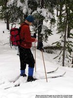
We set our GPS units in the parking lot to track our progress, and in the span of just a few minutes, Bruce commented on how he was getting soaked from the snowfall without his shell on. We were both glad we?d brought waterproof shells, as it looked like we were going to need them. I don?t do nearly as much Nordic skiing as alpine skiing, so trying to figuring out the layering of my clothing is always a little more difficult than getting set for a typical downhill day. I?d brought my gaiters because of the low cut of my ski boots, and I was debating on whether or not I would use them with only the few inches of snow. After discussing it with Bruce, we both decided to use them, and it turned out to be the right choice. Even though the snow wasn?t exceptionally deep, it tended to cake up along our boots because it was a somewhat heavy. In the end, gaiters were the right choice. I really hate it when snow and water sneaks down into your low cut boots, soaks your socks and feet, and makes you cold. Above and beyond comfort, it?s important to keep yourself as dry as possible when you?re out in the backcountry in terms of safety.
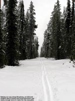
Since Bruce knows the Chief Joseph area fairly well, I was happy to let him lead, while I got a chance to follow and learn more about the trails. He started us off by heading to the left just after the entrance, in the direction of the Broadway trail. We had seen another skier heading off in this direction just as we arrived at the parking area, and we were able to follow his tracks and avoid breaking trail. The new snow provided ample coverage in most areas, but was just barely enough in a few spots. We had to avoid a couple of small rocks, but we were able to get cruising quickly with the pre-made track. I?d forgotten how much fun it was to kick and glide! For the past few weeks I?ve only been on my downhill gear hiking up relatively steep slopes, wearing full skins on fat skis, and carrying a 40 to 50-pound pack full of Ty and his gear. With light touring skis and a small fanny pack that weighed in at just a couple of pounds, I felt like I was flying! In this regard, I was glad that E and the boys hadn?t been able to make the trip this week.")
The signage in the Chief Joseph area was absolutely fantastic. At virtually every intersection, there was a large, colorful, detailed map that clearly showed the layout of the area and where you were within it. I?ve added a picture of one of the maps on the web page for this report for those that want to check it out. When E and I did our trip out to the cabin in the Chief Joseph area back on January 22nd last year, I thought that the great signs were just in the center of the trail network. It?s great to see that they are everywhere.
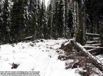
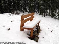
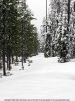
We continued along the Broadway trail for quite a while, and eventually we lost our pre-made track as the other skier broke off to the right towards the cabin. But, even with the addition of breaking trail, the going was easy because the new snow wasn?t too deep. Near the end of Broadway we turned right and headed along the Vista View Trail, which brought us along the north edge of the trail network toward a high point in elevation. Bruce pointed out that we were now on part of the Continental Divide Trail as well, a trail that follows the Continental Divide from Mexico all the way up to Canada. The existing snowpack in this area was well protected from the sun, and large whales of snow were still present on the trail below the new accumulation. We were traveling generally up, but the pace was still quick because we had such a nice base of snow and few underlying obstacles to deal with. We topped out at a bench, and both our GPS units gave an elevation of 7,411 feet, about 130 feet above our starting point. It was hard to tell that I had gained any altitude. It just didn?t feel like it due to such light gear and the fact that I was used to doing far more vertical for alpine runs. I?m not sure where the Vista View name comes from, but even though the bench was the high elevation spot on the trail, there was no big view. There was a nice view of the forest, but we were surrounded by dense pines so there was certainly no big vista where we were located.
After a short pause near the Vista View bench, and a bit of sidestepping as we cautiously navigated the rocks that were assembled in the area, we started the main downhill run to the intersection with the Timber Trail. The downhill was relatively shallow, but with the pitch and curves that were there, I could imagine it being quite a thrill some days on skinny edgeless skis. In our case, the trial wasn?t packed, so we were able to take it slowly as the powder eased us down. Bruce regaled me with stories of many a crash in this area under faster conditions. At the bottom of the hill, we paused for a bite to eat, and then began our final leg on the Timber Trail which would take us back near the parking lot. We passed below the cabin, and then along the south end of the trail network. The sun almost broke out here, and it became bright enough that I had to pull out my sunglasses as I was squinting like crazy. It was interesting to see that in some areas that weren?t protected by trees, the new snow had really consolidated and melted to just a coating. Even though it was cloudy and snowing for the most part, the sun was strong enough to really affect the snow. We?re only a few weeks away from the summer solstice now, so we?re looking at just about the highest sun angle we get in this part of Montana.
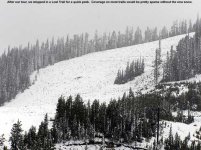
We arrived at the parking lot having really enjoyed the trip. The tour enhanced my knowledge of the Chief Joseph area because we?d done a nice loop around the interior trails I?d seen on my previous trip. While most people were probably cursing the foul rainy weather that had been delivered to the valleys for the holiday weekend, it provided just enough of winter?s bounty up high to make for some fun skiing. Bruce and I both agreed that getting out in the snowfall was far better than moping around down in the rain. We took a look at Lost Trail on way back down the pass, and could see that most slopes aside from north-facing terrain were just about done in terms of skiing. Without the new snowfall, many of them would have had just patchy snow.
Additional pictures from the day, along with a photo I took of one of the Chief Joseph area maps and a plot of the latest snowpack data from the Saddle Mountain SNOTEL station are at:
http://JandEproductions.com/2006/28MAY06.html
J.Spin
In a total reversal of the previous couple of weekends, I found out from my Dad that in Vermont, they were forecast to have clear skies and temperatures in the low 80s F. Vermont?s Mt. Mansfield had seen about 6 new inches of snow during the previous week, and Mt. Washington in New Hampshire had seen about 18 inches of the white stuff. The fair weather meant that people would at least get a chance to get out and enjoy the new snow. The new snowfall had slowed the progress of finally clearing the snow off the Mt. Washington auto road, but a couple of dry days at the end of the week helped them push through. The road was supposedly opened for tour buses and private vehicles as of Saturday, so it looked like the perfect weekend to head up and enjoy car-serviced access to the summit snowfields (which I?ve heard are in really good shape). I?ve already seen one report of car-served Sunday skiing on the Mt. Washington snowfields over at the First Tracks eastern forum, and it sounded pretty good.
Bruce had approached me earlier in the week about the potential for skiing Trapper Peak, the highest point in the central Bitterroots at 10,157 feet. E and I have hiked Trapper Peak in the summer, but we?ve yet to get up there and ski it. Unfortunately, with a vertical rise of 3,000 to 4,000 feet for the hike, and lower portions that require hiking with skis before one can put on their skins, it?s not a practical ski trip to do while carrying the boys in backpacks. Bruce and I kept the option of skiing Trapper on the side, but with winter storm warnings up and heavy precipitation expected, the Bitterroot alpine just wasn?t a really safe place to visit.
On Sunday morning, Bruce called me and suggested the idea of heading for a tour in the Chief Joseph area. The snow depth at the Saddle Mountain SNOTEL (elevation 7,940 feet) had hit a low of 28.6 inches on May 27th, but now it had peaked at 37.2 inches, suggesting as much 8 or 9 inches of accumulation up there. It was kind of nice in a way, because while the weather was nasty enough to keep us out of the alpine; it was also nasty enough to provide a thick coating of fresh snow below tree line. If you follow the link to the pictures for the report, you?ll find a plot of the snowpack depth for the Saddle Mountain SNOTEL so far this season. The snowpack has been dropping quickly over the past few weeks, but this new storm gave it a small reprieve. The snow accumulation at the SNOTEL gave us hope that there would be enough to ski on at Chief Joseph, and while the temperature of around freezing suggested that it might still be sticking, we?d really have to head up to the pass to get the full story. We weren?t even sure if we?d get to ski at all, but we were optimistic.
Since we were just going to be skiing relatively flat terrain, I asked E if she wanted to come and bring the boys in the packs. But, Dylan was fighting a bit of a cold so she decided against it. Thus, it would be just Bruce and I. On the drive to the pass, it was raining lightly in the valley, and I saw the first signs of snow along the road at around 4,000 feet, just after we?d passed through Darby. When we arrived at Chief Joseph Pass (elevation 7,280 feet) it was snowing moderately, and we could see that there were about 4-6 inches of new accumulation in the parking lot area. It didn?t look like there was much in the way of old snowpack left, so we probably wouldn?t have been able to do much skiing without the new snow. When Bruce was up at Chief Joseph about 3 weeks ago, he said there were still several feet of snowpack, so the 90 degree temperatures we?d had a couple of weeks ago must have really melted things out quickly.
We set our GPS units in the parking lot to track our progress, and in the span of just a few minutes, Bruce commented on how he was getting soaked from the snowfall without his shell on. We were both glad we?d brought waterproof shells, as it looked like we were going to need them. I don?t do nearly as much Nordic skiing as alpine skiing, so trying to figuring out the layering of my clothing is always a little more difficult than getting set for a typical downhill day. I?d brought my gaiters because of the low cut of my ski boots, and I was debating on whether or not I would use them with only the few inches of snow. After discussing it with Bruce, we both decided to use them, and it turned out to be the right choice. Even though the snow wasn?t exceptionally deep, it tended to cake up along our boots because it was a somewhat heavy. In the end, gaiters were the right choice. I really hate it when snow and water sneaks down into your low cut boots, soaks your socks and feet, and makes you cold. Above and beyond comfort, it?s important to keep yourself as dry as possible when you?re out in the backcountry in terms of safety.
Since Bruce knows the Chief Joseph area fairly well, I was happy to let him lead, while I got a chance to follow and learn more about the trails. He started us off by heading to the left just after the entrance, in the direction of the Broadway trail. We had seen another skier heading off in this direction just as we arrived at the parking area, and we were able to follow his tracks and avoid breaking trail. The new snow provided ample coverage in most areas, but was just barely enough in a few spots. We had to avoid a couple of small rocks, but we were able to get cruising quickly with the pre-made track. I?d forgotten how much fun it was to kick and glide! For the past few weeks I?ve only been on my downhill gear hiking up relatively steep slopes, wearing full skins on fat skis, and carrying a 40 to 50-pound pack full of Ty and his gear. With light touring skis and a small fanny pack that weighed in at just a couple of pounds, I felt like I was flying! In this regard, I was glad that E and the boys hadn?t been able to make the trip this week.
The signage in the Chief Joseph area was absolutely fantastic. At virtually every intersection, there was a large, colorful, detailed map that clearly showed the layout of the area and where you were within it. I?ve added a picture of one of the maps on the web page for this report for those that want to check it out. When E and I did our trip out to the cabin in the Chief Joseph area back on January 22nd last year, I thought that the great signs were just in the center of the trail network. It?s great to see that they are everywhere.
We continued along the Broadway trail for quite a while, and eventually we lost our pre-made track as the other skier broke off to the right towards the cabin. But, even with the addition of breaking trail, the going was easy because the new snow wasn?t too deep. Near the end of Broadway we turned right and headed along the Vista View Trail, which brought us along the north edge of the trail network toward a high point in elevation. Bruce pointed out that we were now on part of the Continental Divide Trail as well, a trail that follows the Continental Divide from Mexico all the way up to Canada. The existing snowpack in this area was well protected from the sun, and large whales of snow were still present on the trail below the new accumulation. We were traveling generally up, but the pace was still quick because we had such a nice base of snow and few underlying obstacles to deal with. We topped out at a bench, and both our GPS units gave an elevation of 7,411 feet, about 130 feet above our starting point. It was hard to tell that I had gained any altitude. It just didn?t feel like it due to such light gear and the fact that I was used to doing far more vertical for alpine runs. I?m not sure where the Vista View name comes from, but even though the bench was the high elevation spot on the trail, there was no big view. There was a nice view of the forest, but we were surrounded by dense pines so there was certainly no big vista where we were located.
After a short pause near the Vista View bench, and a bit of sidestepping as we cautiously navigated the rocks that were assembled in the area, we started the main downhill run to the intersection with the Timber Trail. The downhill was relatively shallow, but with the pitch and curves that were there, I could imagine it being quite a thrill some days on skinny edgeless skis. In our case, the trial wasn?t packed, so we were able to take it slowly as the powder eased us down. Bruce regaled me with stories of many a crash in this area under faster conditions. At the bottom of the hill, we paused for a bite to eat, and then began our final leg on the Timber Trail which would take us back near the parking lot. We passed below the cabin, and then along the south end of the trail network. The sun almost broke out here, and it became bright enough that I had to pull out my sunglasses as I was squinting like crazy. It was interesting to see that in some areas that weren?t protected by trees, the new snow had really consolidated and melted to just a coating. Even though it was cloudy and snowing for the most part, the sun was strong enough to really affect the snow. We?re only a few weeks away from the summer solstice now, so we?re looking at just about the highest sun angle we get in this part of Montana.
We arrived at the parking lot having really enjoyed the trip. The tour enhanced my knowledge of the Chief Joseph area because we?d done a nice loop around the interior trails I?d seen on my previous trip. While most people were probably cursing the foul rainy weather that had been delivered to the valleys for the holiday weekend, it provided just enough of winter?s bounty up high to make for some fun skiing. Bruce and I both agreed that getting out in the snowfall was far better than moping around down in the rain. We took a look at Lost Trail on way back down the pass, and could see that most slopes aside from north-facing terrain were just about done in terms of skiing. Without the new snowfall, many of them would have had just patchy snow.
Additional pictures from the day, along with a photo I took of one of the Chief Joseph area maps and a plot of the latest snowpack data from the Saddle Mountain SNOTEL station are at:
http://JandEproductions.com/2006/28MAY06.html
J.Spin