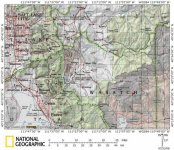
Well, it may not be about skiing, but in the off-season these posts provide a chance for me to show out-of-staters a bit more of Utah's scenic gems. This weekend was spent camping and fishing at Currant Creek Reservoir in the Uinta National Forest some 15 miles due north of Strawberry Reservoir and 19 gravel road miles north of US 40 about halfway between Heber City and Duschene (I've provided a rough map below). The turn-off from US 40 is just west of Fruitland.
This post also has some OSC (obligatory ski content):
1. Along the road in from U.S. 40 through Currant Creek Canyon sat a nearly-new Bombardier snowcat at a trailhead on the east side of the road, opposite Water Hollow, complete with a passenger cabin on the back. Could that be someone's private snowcat skiing stash? There are no commercial operators at all out that way. (Somehow I didn't even think to take a photo. ) My topo map shows a network of jeep roads from there eventually leading to the 10,000 foot level at Raspberry Ridge east of the reservoir and outside of the National Forest boundary.
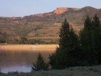
2. There were still patches of snow visible along the high ridges surrounding the reservoir, including on 10,554-foot Currant Creek Peak.
On Saturday morning we packed the truck full, including The Princess, The Kid, The Kid's friend Dean, and our two dogs (chocolate lab named Zach and golden retriever named Buddy) in addition to all of our car-camping gear. We didn't leave until then because we went up to Utah Olympic Park on Friday night to witness the inaugural Continental Cup women's ski jumping competition (a terrific event to attend, but that's a whole different story).
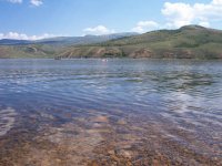
That 19 miles of gravel is a long, dusty route leading up Currant Creek Canyon from where the creek meets US 40 (The Princess found out just how long that is when she decided to drive back out to the store at the intersection for a deck of cards and it took her 2 full hours to do so!). It's entirely uninhabited save for one large valley ranch about a third of the way up. It gradually climbs back northwest from desert along US 40 at 6,600 feet to a mix of sub-Alpine forest and sage brush, depending on which way the hillside faces, at the lake level of 7.687 feet. About halfway up the canyon you cross into the Uinta National Forest.
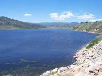
Currant Creek Reservoir is primarily used to store water for irrigation and flood prevention, created with the building of the dam in 1974-75 as a Bureau of Reclamation project that is now operated by the Central Utah Water Conservation District. The Vat Tunnel is 8.25 feet in diameter and extends from the northern end of the reservoir for 7.3 miles under several mountain ridges, including a 10,000-foot shoulder of Red Creek Mountain, before depositing its flow into the West Branch of the Duschene River. It was built from 1975 to 1983. The Currant Creek itself flows into the Strawberry River south of US 40, but the Currant Tunnel, Layout Tunnel and Water Hollow Tunnel connect in a series of 13-foot diameter conduits beginning just below the dam that connect the water flow with the 17,000-acre Strawberry Reservoir after an amazing 9.25 miles under a series of 9,000-foot ridges. These tunnels were completed in the 1970s, in conjunction with the dam. From Strawberry Reservoir, water is transported via the 3.8-mile Strawberry Tunnel under the Wasatch divide to Diamond Fork, a tributary of the Spanish Fork River, thus diverting irrigation water from the Colorado Basin to the Bonneville Basin to irrigate agricultural land in the southern Utah Valley near Spanish Fork.
My intent had been to camp on our own somewhere amongst the coves at the northern end of the reservoir, but the sun and temperatures are warm this July and there was no shade, so The Princess forced us to instead switch gears to camp amongst pines and aspens at the state campground established at the southwestern corner of the lake, near the dam. I'm not a fan of car-camping, much less campground camping, so I wasn't thrilled with this development. :evil:
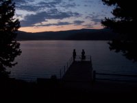
There were, however, worse options than this one. The campground design didn't pack us in too tightly with most of our neighbors, and you could scramble down a steep north-facing 30-foot bank right behind the tent to access a cove of the reservoir. The main body of the reservoir, just above the dam, was only a 75-yard walk to the east of our tent site.
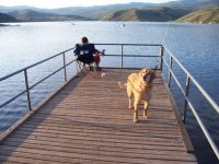
It's deer fly season, and while they were incredibly annoying they were nothing that a liberal application of 100% DEET couldn't handle. The Kid and Dean and the dogs swam in the afternoon heat until the sun got low and activities turned to fishing.
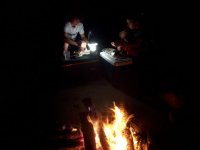
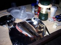
The Kid has precious little fishing experience, and it was therefore welcome that Dean was along so that I didn't have to do all of the teaching. Besides, he's far more likely to listen to Dean than he is me. I didn't do much fishing myself as I let The Kid spend time with my gear. Currant Creek Reservoir didn't live up to its reputation for fish practically jumping onto your hook, yet The Kid and Dean each caught a respectable rainbow trout, two of the few caught by campers in the campground this weekend. They each got to enjoy their catch by the campfire last night.
One word of advice: make sure that your air mattress doesn't leak. Ours did. In fact, the sucker is a good 2 feet thick when inflated, so when it starts to deflate your body starts forming ridiculous contortions. About 1:30 a.m. I finally gave up and moved my sleeping bag to the hard tent floor. I somehow managed to find a spot free of any significant rocks or other painful objects.
Both kids got up early again this morning to fish without success. Some more swimming in the chilly (55-degree?) water today was on the kids' and dogs' itinerary before we broke camp and headed for home. It was toasty up there under the sun during the day, but was comfortable in the shade, and at night you needed a polar fleece if you were away from the campfire. Yet down here today it was 101 in the Salt Lake Valley upon our return.
Another gorgeous Utah weekend in the outdoors.
This post also has some OSC (obligatory ski content):
1. Along the road in from U.S. 40 through Currant Creek Canyon sat a nearly-new Bombardier snowcat at a trailhead on the east side of the road, opposite Water Hollow, complete with a passenger cabin on the back. Could that be someone's private snowcat skiing stash? There are no commercial operators at all out that way. (Somehow I didn't even think to take a photo.
) My topo map shows a network of jeep roads from there eventually leading to the 10,000 foot level at Raspberry Ridge east of the reservoir and outside of the National Forest boundary.2. There were still patches of snow visible along the high ridges surrounding the reservoir, including on 10,554-foot Currant Creek Peak.
On Saturday morning we packed the truck full, including The Princess, The Kid, The Kid's friend Dean, and our two dogs (chocolate lab named Zach and golden retriever named Buddy) in addition to all of our car-camping gear. We didn't leave until then because we went up to Utah Olympic Park on Friday night to witness the inaugural Continental Cup women's ski jumping competition (a terrific event to attend, but that's a whole different story).
That 19 miles of gravel is a long, dusty route leading up Currant Creek Canyon from where the creek meets US 40 (The Princess found out just how long that is when she decided to drive back out to the store at the intersection for a deck of cards and it took her 2 full hours to do so!). It's entirely uninhabited save for one large valley ranch about a third of the way up. It gradually climbs back northwest from desert along US 40 at 6,600 feet to a mix of sub-Alpine forest and sage brush, depending on which way the hillside faces, at the lake level of 7.687 feet. About halfway up the canyon you cross into the Uinta National Forest.
Currant Creek Reservoir is primarily used to store water for irrigation and flood prevention, created with the building of the dam in 1974-75 as a Bureau of Reclamation project that is now operated by the Central Utah Water Conservation District. The Vat Tunnel is 8.25 feet in diameter and extends from the northern end of the reservoir for 7.3 miles under several mountain ridges, including a 10,000-foot shoulder of Red Creek Mountain, before depositing its flow into the West Branch of the Duschene River. It was built from 1975 to 1983. The Currant Creek itself flows into the Strawberry River south of US 40, but the Currant Tunnel, Layout Tunnel and Water Hollow Tunnel connect in a series of 13-foot diameter conduits beginning just below the dam that connect the water flow with the 17,000-acre Strawberry Reservoir after an amazing 9.25 miles under a series of 9,000-foot ridges. These tunnels were completed in the 1970s, in conjunction with the dam. From Strawberry Reservoir, water is transported via the 3.8-mile Strawberry Tunnel under the Wasatch divide to Diamond Fork, a tributary of the Spanish Fork River, thus diverting irrigation water from the Colorado Basin to the Bonneville Basin to irrigate agricultural land in the southern Utah Valley near Spanish Fork.
My intent had been to camp on our own somewhere amongst the coves at the northern end of the reservoir, but the sun and temperatures are warm this July and there was no shade, so The Princess forced us to instead switch gears to camp amongst pines and aspens at the state campground established at the southwestern corner of the lake, near the dam. I'm not a fan of car-camping, much less campground camping, so I wasn't thrilled with this development. :evil:
There were, however, worse options than this one. The campground design didn't pack us in too tightly with most of our neighbors, and you could scramble down a steep north-facing 30-foot bank right behind the tent to access a cove of the reservoir. The main body of the reservoir, just above the dam, was only a 75-yard walk to the east of our tent site.
It's deer fly season, and while they were incredibly annoying they were nothing that a liberal application of 100% DEET couldn't handle. The Kid and Dean and the dogs swam in the afternoon heat until the sun got low and activities turned to fishing.
The Kid has precious little fishing experience, and it was therefore welcome that Dean was along so that I didn't have to do all of the teaching. Besides, he's far more likely to listen to Dean than he is me. I didn't do much fishing myself as I let The Kid spend time with my gear. Currant Creek Reservoir didn't live up to its reputation for fish practically jumping onto your hook, yet The Kid and Dean each caught a respectable rainbow trout, two of the few caught by campers in the campground this weekend. They each got to enjoy their catch by the campfire last night.
One word of advice: make sure that your air mattress doesn't leak. Ours did. In fact, the sucker is a good 2 feet thick when inflated, so when it starts to deflate your body starts forming ridiculous contortions. About 1:30 a.m. I finally gave up and moved my sleeping bag to the hard tent floor. I somehow managed to find a spot free of any significant rocks or other painful objects.
Both kids got up early again this morning to fish without success. Some more swimming in the chilly (55-degree?) water today was on the kids' and dogs' itinerary before we broke camp and headed for home. It was toasty up there under the sun during the day, but was comfortable in the shade, and at night you needed a polar fleece if you were away from the campfire. Yet down here today it was 101 in the Salt Lake Valley upon our return.
Another gorgeous Utah weekend in the outdoors.
Attachments
-
 06 currant creek res raft.jpg58.5 KB · Views: 2,470
 -
 05 currant creek res dinner.jpg34.8 KB · Views: 2,465
 -
 04 currant creek res trout catch.jpg54.6 KB · Views: 2,463
 -
 03 currant creek res dean kid fish dusk.jpg49 KB · Views: 2,463
 -
 02 currant creek res dam sunset.jpg54.4 KB · Views: 2,474
 -
 01 currant creek res sundown kid fish buddy.jpg59.4 KB · Views: 2,460
 -
 01 currant creek res from dam.jpg55.7 KB · Views: 2,465
 -
 currant creek map.JPG78.4 KB · Views: 2,464