salida
New member
Hi Guys.
I don't think any one on the boards skis around here, but I thought I'd post this TR none-the-less.
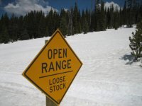
Am staying in Saratoga, on the North Platte (where the trout are bigger than humans) and decided to go skiing while my pops is at a conference. Headed down route 230, to 130 and up to the Medicine Bowes. Decided it would be medicine bow peak itself, at about 12,500.
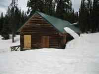
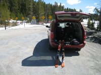
Drove to where the road is gated, about 4 or 5 miles from the top of the pass. They are plowing the road however the gate was still closed.
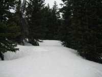
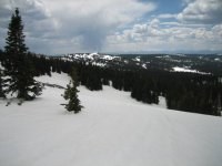
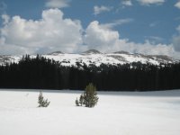
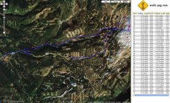
Put my skins on my skis and headed up the pass at around 10 am. Was skiing a moderate grade along side the road, and after about 2.5 miles I ran into 2 guys who were testing snowmobiles for polaris. I got a ride from one of them up through the flat lands (another 3 miles) to the edge of medicine bow peak. Skinned up the ridge line to the saddle between one of the three false peaks. Topped out around 12000, slightly above treeline. From the top I cuold see the road, and where I would need to ski out to to find my car. Glad I had my bearings.
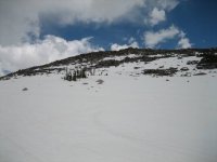
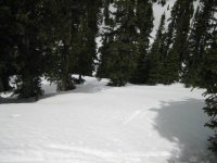
Stopped at the saddle for a lunch around 1, and took the skins off. Skied down the ridge (quite steep, maybe 40 degrees) through some chutes/glades. Got down on the flats and into a drainage, following some snowmobile tracks that I thought were the ones that took me up. Ended up following a stream that turned into a raging meltwater river. And apparently got off track. I had a compass heading from the top of the col, and also some ATV maps I'd picked up a ranger station. Eventually, I got to a part in the trail where I'd have to cross the river, and my snow was quickly running out.
Had to ford the stream with my ski boots, about waist deep, and mighty cold. Skinned my way out to the snowline around 9000 feet. Probably skied about 6 miles. The trail eventually led to a dirt road labeled 234, which turned out to be one of the ATV trails. I read on my map that it would dump out about 5 miles down road from my car, and about 2 miles up road from the small town of Ryan Park. I huffed it out in my ski boots (because I didnt bring shoes thinking I'd be in snow the whole time) about 4 miles, and then down route 130 another 2 miles in my ski boots. I got to Ryan Park around 545, and talked a fellow into driving me back to my car in exchange for a 6 pack of PBR. (I think he might have thought it was a better deal than I did, nearly impossible to believe).
All in all a fun yet incredibly arduous day. To much walking in ski boots. 18 and a half miles total, about 3 of them on snow mobile.
Pictures below.
-Porter
PS I didn't take pictures of the dirt road, I was to disgruntled!
I don't think any one on the boards skis around here, but I thought I'd post this TR none-the-less.
Am staying in Saratoga, on the North Platte (where the trout are bigger than humans) and decided to go skiing while my pops is at a conference. Headed down route 230, to 130 and up to the Medicine Bowes. Decided it would be medicine bow peak itself, at about 12,500.
Drove to where the road is gated, about 4 or 5 miles from the top of the pass. They are plowing the road however the gate was still closed.
Put my skins on my skis and headed up the pass at around 10 am. Was skiing a moderate grade along side the road, and after about 2.5 miles I ran into 2 guys who were testing snowmobiles for polaris. I got a ride from one of them up through the flat lands (another 3 miles) to the edge of medicine bow peak. Skinned up the ridge line to the saddle between one of the three false peaks. Topped out around 12000, slightly above treeline. From the top I cuold see the road, and where I would need to ski out to to find my car. Glad I had my bearings.
Stopped at the saddle for a lunch around 1, and took the skins off. Skied down the ridge (quite steep, maybe 40 degrees) through some chutes/glades. Got down on the flats and into a drainage, following some snowmobile tracks that I thought were the ones that took me up. Ended up following a stream that turned into a raging meltwater river. And apparently got off track. I had a compass heading from the top of the col, and also some ATV maps I'd picked up a ranger station. Eventually, I got to a part in the trail where I'd have to cross the river, and my snow was quickly running out.
Had to ford the stream with my ski boots, about waist deep, and mighty cold. Skinned my way out to the snowline around 9000 feet. Probably skied about 6 miles. The trail eventually led to a dirt road labeled 234, which turned out to be one of the ATV trails. I read on my map that it would dump out about 5 miles down road from my car, and about 2 miles up road from the small town of Ryan Park. I huffed it out in my ski boots (because I didnt bring shoes thinking I'd be in snow the whole time) about 4 miles, and then down route 130 another 2 miles in my ski boots. I got to Ryan Park around 545, and talked a fellow into driving me back to my car in exchange for a 6 pack of PBR. (I think he might have thought it was a better deal than I did, nearly impossible to believe).
All in all a fun yet incredibly arduous day. To much walking in ski boots. 18 and a half miles total, about 3 of them on snow mobile.
Pictures below.
-Porter
PS I didn't take pictures of the dirt road, I was to disgruntled!