I didn't show up in Skidog's report from this weekend because we opted to take one more backpacking trip to the desert before it gets too hot.
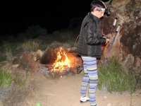
Patricia had expressed an interest in trying backpacking for the first time. We've been car camping together, but honestly her idea of camping is to set up a 45-foot RV in a park. I, on the other hand, want to hike in to a place where I won't see another soul until I get back to my truck, at the very least.
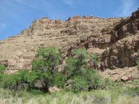
Desolation Canyon seemed on paper to be one of those places. It's an 85-mile stretch of the Green River between Vernal and the town of Green River in eastern Utah. In that whole 85-mile stretch there are only two places where it's reasonably possible to access Desolation Canyon by land. The first, near the northern end, is Sand Wash, a popular put-in for rafters and kayakers lucky enough to secure a permit to run the Green. Our access would be from the second option, near the southern end.
Our first mistake was to follow a guidebook's recommendation for access to the Turtle Canyon WSA, adjacent to our destination within the Desolation Canyon WSA, which involved ascending Horse Canyon to the crest of the Book Cliffs, then descending the other side via Little Horse Canyon to the Range Creek drainage, then following Range Creek down through Wilcox Ranch to the trailhead. The road quickly deteriorated as we passed the abandoned Geneva coal mine. At least it probably could've been called a road until a few years before they stopped maintaining it. It was heavily eroded and barely one lane wide, narrower where snow drifts still lingered, and progress was slow for five miles past increasingly massive drop-offs before we were surprised to encounter another vehicle heading down. I ran my truck up the inside embankment to barely create enough room for the other vehicle to pass. Its driver, a colorful woman in her 50s, stopped to chat. It turned out that she was one of the ranch managers in Range Creek, and informed me that contrary to both my guidebook and the advice from the BLM rangers in Price there were three locked gates blocking my planned route through Range Creek Canyon. She bummed a smoke, we thanked her, and turned around at the pass -- about the only spot with enough room -- frustrated that we'd gone a good 45 minutes out of our way.
The alternative to gain access, another dirt road that by my research didn't even go through, turned out to be 29 miles long and in even worse shape than the Horse Canyon Road. It ascends the Book Cliffs from south of E Carbon and traverses the mid-plateau of the cliffs southward to somewhere east of Woodside before it turns east to crest the summit ridge and drop into the Range Creek drainage via Turtle Canyon, ending 3 miles from the Range Creek Rapids on the Green at the Desolation Canyon WSA boundary.
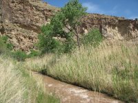
It took 3 hrs to drive that 29 miles, requiring a stop every 50 yards or so to ease over another washout in the road. The last 2.5 miles was on a spur trail heading east along the Range Creek that the BLM signed as a "very difficult 4x4 trail". It included 4 fords across a very swiftly running Range Creek. It was the first time I've ever forded a stream in the truck, something that turned out to be rather fun.
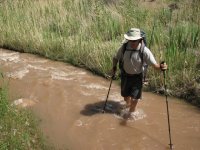
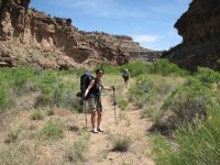
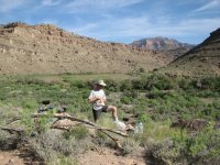
The next phase of our journey was a 3-mile hike that involved another 15 thigh-deep fords (each way!) on foot. I eventually gave up on changing footwear each time and resigned myself to hiking in saturated boots.
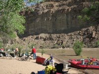
In that whole 29 miles we only saw one other vehicle, and it was going the other way maybe only 5 miles in, so I was sure that we were getting the solitude I wanted...until a half mile from the end of the hike when I rounded a corner in the trail and saw 8 people standing there looking around. :roll: It turns out that they were a river party who decided to choose the Range Creek Canyon, of all places, to set up camp for the night. No matter, they were nice people and with their camp established a quarter mile away you couldn't see or hear them, but I still knew they were there. A big plus was that their leader donated to us an ice cold keg-can of Heineken, a rare backpacking luxury! Beer never tasted that good.
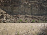
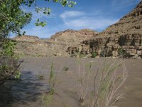
The river was running huge and all of the beaches were underwater. The rafters had the only nice, sandy, shaded campsite along the rapids that wasn't underwater. They invited us to use a small section next to them but I politely declined. We ended up on small ridge about a quarter mile back from the river (but only 200 feet from Range Creek) where we baked in the sweltering sun and were attacked by voracious gnats and aggressive silver flies.
I don't think that Patricia is going to be asking to come along again anytime soon.
Patricia had expressed an interest in trying backpacking for the first time. We've been car camping together, but honestly her idea of camping is to set up a 45-foot RV in a park. I, on the other hand, want to hike in to a place where I won't see another soul until I get back to my truck, at the very least.
Desolation Canyon seemed on paper to be one of those places. It's an 85-mile stretch of the Green River between Vernal and the town of Green River in eastern Utah. In that whole 85-mile stretch there are only two places where it's reasonably possible to access Desolation Canyon by land. The first, near the northern end, is Sand Wash, a popular put-in for rafters and kayakers lucky enough to secure a permit to run the Green. Our access would be from the second option, near the southern end.
Our first mistake was to follow a guidebook's recommendation for access to the Turtle Canyon WSA, adjacent to our destination within the Desolation Canyon WSA, which involved ascending Horse Canyon to the crest of the Book Cliffs, then descending the other side via Little Horse Canyon to the Range Creek drainage, then following Range Creek down through Wilcox Ranch to the trailhead. The road quickly deteriorated as we passed the abandoned Geneva coal mine. At least it probably could've been called a road until a few years before they stopped maintaining it. It was heavily eroded and barely one lane wide, narrower where snow drifts still lingered, and progress was slow for five miles past increasingly massive drop-offs before we were surprised to encounter another vehicle heading down. I ran my truck up the inside embankment to barely create enough room for the other vehicle to pass. Its driver, a colorful woman in her 50s, stopped to chat. It turned out that she was one of the ranch managers in Range Creek, and informed me that contrary to both my guidebook and the advice from the BLM rangers in Price there were three locked gates blocking my planned route through Range Creek Canyon. She bummed a smoke, we thanked her, and turned around at the pass -- about the only spot with enough room -- frustrated that we'd gone a good 45 minutes out of our way.
The alternative to gain access, another dirt road that by my research didn't even go through, turned out to be 29 miles long and in even worse shape than the Horse Canyon Road. It ascends the Book Cliffs from south of E Carbon and traverses the mid-plateau of the cliffs southward to somewhere east of Woodside before it turns east to crest the summit ridge and drop into the Range Creek drainage via Turtle Canyon, ending 3 miles from the Range Creek Rapids on the Green at the Desolation Canyon WSA boundary.
It took 3 hrs to drive that 29 miles, requiring a stop every 50 yards or so to ease over another washout in the road. The last 2.5 miles was on a spur trail heading east along the Range Creek that the BLM signed as a "very difficult 4x4 trail". It included 4 fords across a very swiftly running Range Creek. It was the first time I've ever forded a stream in the truck, something that turned out to be rather fun.
The next phase of our journey was a 3-mile hike that involved another 15 thigh-deep fords (each way!) on foot. I eventually gave up on changing footwear each time and resigned myself to hiking in saturated boots.
In that whole 29 miles we only saw one other vehicle, and it was going the other way maybe only 5 miles in, so I was sure that we were getting the solitude I wanted...until a half mile from the end of the hike when I rounded a corner in the trail and saw 8 people standing there looking around. :roll: It turns out that they were a river party who decided to choose the Range Creek Canyon, of all places, to set up camp for the night. No matter, they were nice people and with their camp established a quarter mile away you couldn't see or hear them, but I still knew they were there. A big plus was that their leader donated to us an ice cold keg-can of Heineken, a rare backpacking luxury! Beer never tasted that good.
The river was running huge and all of the beaches were underwater. The rafters had the only nice, sandy, shaded campsite along the rapids that wasn't underwater. They invited us to use a small section next to them but I politely declined. We ended up on small ridge about a quarter mile back from the river (but only 200 feet from Range Creek) where we baked in the sweltering sun and were attacked by voracious gnats and aggressive silver flies.
I don't think that Patricia is going to be asking to come along again anytime soon.
Attachments
-
 16 desolation cyn range creek canyon 080601.jpg104.9 KB · Views: 2,547
 -
 15 desolation cyn flowering cactus 080601.jpg106.9 KB · Views: 2,549
 -
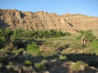
 14 desolation cyn range creek 080601.jpg108 KB · Views: 2,545
 -
 13 desolation cyn range creek ford todd 080601.jpg103.5 KB · Views: 2,555
 -
 12 desolation cyn range creek canyon 080601.jpg108.3 KB · Views: 2,544
 -
 11 desolation cyn lizard 080601.jpg107.3 KB · Views: 2,557
 -
 10 desolation cyn range creek rapids 080601.jpg105.1 KB · Views: 2,548
 -
 09 desolation cyn riverside forest 080601.jpg108.2 KB · Views: 2,548
 -
 08 desolation cyn range creek rapids 080601.jpg92.2 KB · Views: 2,542
 -
 07 desolation cyn rafters camp 080601.jpg105.8 KB · Views: 2,548
 -
 06 desolation cyn todd making breakfast 080601.jpg105.9 KB · Views: 2,566
 -
 05 desolation cyn patricia at fire 080531.jpg107.6 KB · Views: 2,552
 -
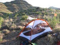 04 desolation cyn patricia in tent 080531.jpg107.2 KB · Views: 2,548
 -
 03 desolation cyn sunset from camp 080531.jpg106.1 KB · Views: 2,549
 -
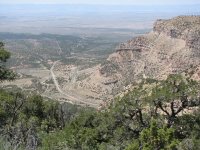 02 desolation cyn atop book cliffs 080531.jpg104.4 KB · Views: 2,560
 -
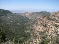 01 desolation cyn road ascending 20080531.jpg106 KB · Views: 2,565
")
") obviously that was a joke
obviously that was a joke