Hi there, I might be able to provide some more insight as I'm from Northern BC. I found your board in my search for information on skiing in the States and was a bit surprised to see someone asking about Shames! I haven't skied Shames myself, but I have skied Smithers a few times and many years at Powder King.
To qualify any opinions, I haven't spent a lot of time skiing anywhere else except for one full season at Whistler/Blackcomb last year and a handful of times each at Silverstar, Big White, Sun Peaks and Mt Baker. I can tell you for sure that while the terrain at Smithers or Powder King (I am not sure about Shames) is not as steep as Whistler, the snow more than makes up for it in my mind - for Powder King, think quantity like Mt Baker, but dryer - PK claims 40+ feet a year, but one year I skiied there it had to have been more, it snowed every week from late November through late February, 1 to 2 feet a week. For Smithers, think very dry powder, but not as much. I had a handful of days of what I consider good snow at Whistler last year and the rest is what I think is coastal crud... cement even sometimes.
The links provided earlier talk quite a bit about Shames and Smithers so I won't say much more about them other than that I had a friend spend a season at Shames (who grew up with me at PK) and said that the terrain was better but the snow wasn't as dry - although there was plenty of it! But it is close to the coast so be prepared for the odd warm/wet spell.
Powder King is located near the east arm of Williston Lake which is a quite large lake in northern BC created by a hydro dam. I'm not sure what it is about the area, but it is in a known snow-belt and consistently gets a lot of snow. Some years the snow is dry right from December through March with no melting although that doesn't happen as often lately. I was skiing the peak of PK the last weekend of May this year and could have kept skiing it well into June if I had been willing to hike farther before putting the skins on. I have had many memorable snow days at PK where if you took your skis/board off you would dissappear in the snow pack because it can snow a meter or more at a time before the snow has a chance to consolidate. On any given powder day the line up won't be more than a few minutes and you will have fresh tracks on the hill until lunchtime. After that you can hike the peak and go ride some lines out of bounds (very relaxed OB policy.) As mentioned before the terrain isn't as steep in most places as Whistler, but there are definetely some fun sections to be had: the Kitchen Window to skier's left from the peak (can be seen from the t-line), below this is an area called the Black Forest. It is decent tree skiing and you can generally find your own turns well into the day, make sure to cut out near the bottom of the t-bar. Some people do ski it further down past until they pop into the clearing for the power lines and hike back up to Penny Lane.
If you ski off the peak near the shack just skier's right there are some short nice tree lines in little chutes that lead down into a wide flat bowl. The drainage going out of the bowl (out of bounds to skiers right of the area, past the last run called Satisfaction) is known as the Elevator Shaft. All of the slopes leading down into the drainage are quite steep, but be careful as I have seen evidence of sluffs at the bottom of the creek (luckily haven't been in any myself.)
Another nice area is further skier's right to the side of the Elevator Shaft and is known as 86er's - this whole slope faces the opposing mountains directly and is naturally gladed by the large amounts of snowfall. Tree spacing becomes generous and you can really rip it up. It isn't especially steep but it has enough slope that you can get moving and lay down some nice turns. A key thing to note is that if you do go out of bounds past Satisfaction into the Elevator Shaft and 86er's, you have to traverse to get back to the lifts without having to walk - if anyone has gone into the woods before you it will be obvious where to cut out - even though the slopes below this line will largely be untracked, don't go further unless you are prepared to skin/walk out. It takes about 1/2 to an hour to get back to the resort via that method.
If you have time and a friend to do some shuttling, get him/her to pick you up from the side of the highway (heading back to Prince George from PK) at the bottom of the Easter run. To get to this area, you have to hike/skin up a peak that is 90 degrees to the right from the peak of PK when you are on top of PK looking at the Murray range across from the ski hill. It is the south peak from the ski hill in this link ->
http://maps.google.ca/maps?f=q&hl=en&q= ... 4&t=h&om=1
I have had some absolutely fabulous turns down the top half of this slope, but be prepared to whack through willows if it is before January when you get to the bottom. Generally on the drive up you can tell if it will be ok to ski that far down or not. People at the hill are usually pretty friendly and if you ask around you can usually find someone willing to show you the goods. For the really adventurous and if the stability is right, you can can go across the valley to the Murray's and skin up. The highway goes right near the bottom of the mountains just past Powder King as the highway drops back down to Azuzetta Lake.
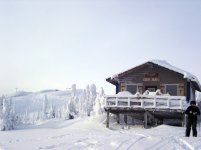
Accomodations at the hill are quite limited so you usually have to either camp in your RV (or tent!) or try to get into the hotel ATCO (although I hear they are sprucing it up a bit this year). There are some private cabins on the hill for rent at decent prices - ask around in the bar and they can direct you to the right person. If all else fails, Mackenzie is about a 45 minute drive away.
The only way to get to Powder King or Smithers is to drive. If you are driving through Vancouver and want to ski Shames/Smithers, it's probably easiest to take the ferry from Vancouver up the coast. The drive from Vancouver to Prince George is about 10 hours in the winter, and from PG to Powder King is 2 hours north, and 4 hours west to Smithers. Shames is a further 2 hours or so from Smithers.
If you're going to spend some time up here and don't mind earning your turns, another place to try is Red mountain and the Farm, both north-east of Prince George. There are two backcountry cabins - I haven't stayed at either so unfortunately don't know what they look like. I have stayed across the valley in the cabins at Raven Lake and Grizzly Den though and have also camped on Viking Ridge. Red and the Farm are in the McGregor's and Raven Lake is in the Cariboo's.
A few links to read up on the above areas:
http://www.powderking.com/
http://www.bchydro.com/info/res_hydromet/data/pyn.txt - real time snow data (1mm = 1cm snow roughly)
http://www.env.gov.bc.ca/bcparks/explor ... sugar.html
http://maps.google.ca/maps?f=q&hl=en&q= ... iwloc=addr
Viking Ridge is at the top and Raven Lake/Grizzly Den is at the bottom.
http://maps.google.ca/maps?f=q&hl=en&q= ... 8&t=h&om=1
this is the Farm/Fang/Torpy area
http://maps.google.ca/maps?f=q&hl=en&q= ... 195694&t=h
and this is the Red mountain area
Unfortunately I couldn't find the links to the info about the cabins at these last two areas but will keep digging. The Viking Ridge area can be accessed from the highway but won't have good coverage at the bottom until January generally (after that it is 1100m of vertical.) Access to Raven Lake and the Farm areas is a bit harder and usually requires a sled to get in on the forest service roads as they usually aren't plowed in winter. Red mountain requires you to pass through private land in the very small community of Penny and usually requires a contact from Prince George to get you through. I realize the last stuff isn't very detailed, but I just wanted to give you a broader idea of what is available in northern BC. If you want more information I have topographic maps and more detailed access information for most of the above areas.
Oh yeah, also try the forums at the Canadian Avalanche Association's website - Smithers and Shames are covered in the Skeena/Babine region and Powder King and the Farm areas are covered in the Northern Rockies region.
http://www.avalanche.ca/default.aspx?DN ... ,Documents
and of course the CAA's website itself for general forecasts of weather and avi conditions - they cover a broad area though so you really need to assess the snowpack yourself. Two kids didn't on Raven Peak across from the Raven Lake cabin in the mid 90's and one of them died because of it.
Anywho, thought i'd kick my two cents in!
Cheers and happy riding this year,
Andrew
 / We discused Shames and he mentioned that he found of whole bunch of stuff on the backcountry. Hope, he puts some of that stuff here.
")