Telluride Expansion for 2008-09: Revelation Bowl

ChrisC

Well-known member
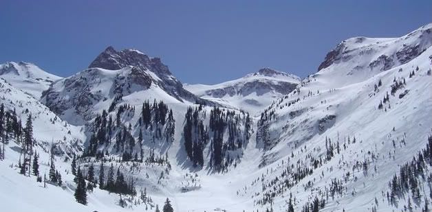
Telluride announced that it will add a new Quad chair to serve Revelation Bowl.


RevelationBowl.jpg


This is an important expansion for the following reasons:

1. Telluride now has a 3,845 vertical feet lift-served or 4,425 feet with hiking. For lift-served areas, Telluride now is #2 in the United States only behind Jackson Hole. (Big Sky vertical - while claiming 4000+, is unksiable).


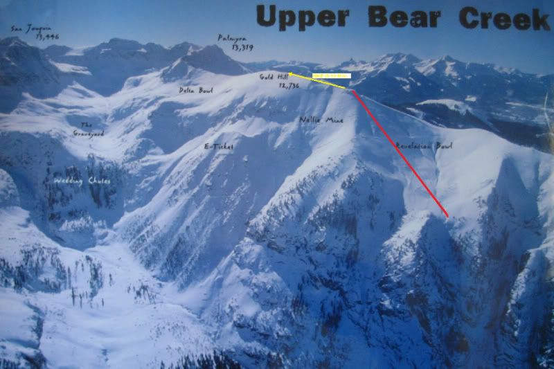
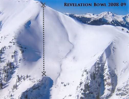
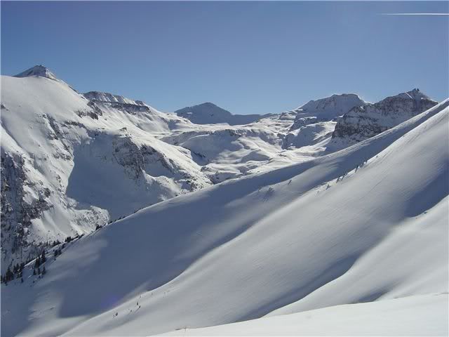
2. Revelation Bowl. While not huge in scale, it is 400 acres/850 vert of Northeast facing terrain located at the 11500-13000 ft. elevation ball-park with large quantities of blow-in snow from typcial SW storm flow. The terrain is mostly upper intermediate/low expert with one groomed route.
Rev2-1.jpg


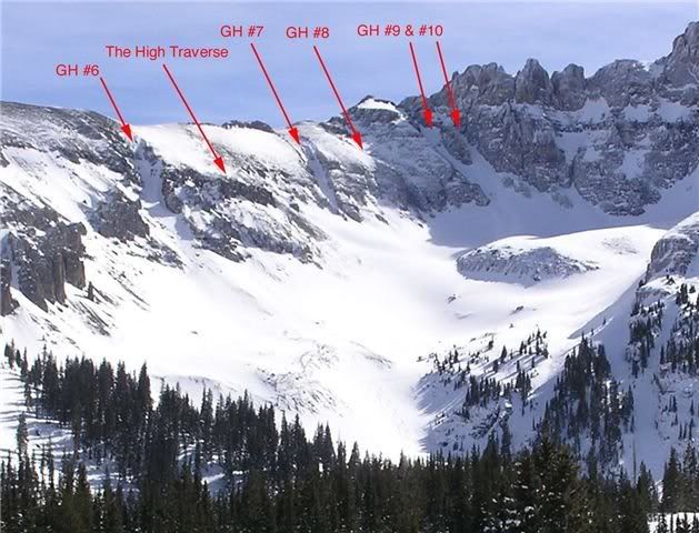
3. Gold Hill 6-10 now lift-served. This expert terrain can be reached with a short 100 ft. vertical hike.
GoldHill6-10.jpg


4. Bear Creek gate now lift-served.
Now Bear Creek is complete slackcountry. This is some of the best in US. (Negative aside: Since it will now be so obvious with more gapers and less educated, I suspect Telluride should have a pretty massive slide in the next 1-3 years.)
BearCreek-1.jpg
 
Chris,

For #4, which part is now lift accessed. The stuff front & Center in the pic, the stuff on the right side of the pic.... etc.. ? If front & Center, looks a bit short but nice.
 
EMSC":3vn2bodp said:
Chris,

For #4, which part is now lift accessed. The stuff front & Center in the pic, the stuff on the right side of the pic.... etc.. ? If front & Center, looks a bit short but nice.

The entire area of Bear Creek is now lift-accessed (with a minor hike via the gate). You can almost traverse the entire bowl/drainage and pick your line.

It is hard to capture Bear Creek scope in one pic since it is 4,000 vertical feet from summit to town. The bottom ends in town about 1-2 blocks from the Oak Street Lift / Gondola base.

Here is a map sold in town. The vertical in the Upper Bear Creek photo is about 2500-2800 ft. until you get to a significant bench seen in the photo - followed by a some more rolls and small rapel. There is a low angle run out into town on a popular hiking path full of humans and dogs year round.

IMG_3226.jpg
 
I got that press release last week, but couldn't tell how much extra vertical/access had been added. It looks significant from ChrisC's description. Very helpful pictures, showing that the Revelation drainage cliffs out below the lift, so you must go farther east to make it all the way into town.

I would think they will have to put a gate up there for Bear Creek in its current uncontrolled state, and it will probably closed a lot of the time with the SW Colorado snowpack.

But put a couple of lifts into the alpine area in that picture and then Telluride might belong in the conversation with Jackson, Squaw etc. for terrain. Lifts and skier packing would also help snow stability. It shouldn't be any more difficult to maintain than Highlands Bowl.

I still don't know why I neglected to ask our NASJA hosts in 2004 if we could get a guided tour in Bear Creek. It hadn't snowed in 3 weeks and we had been in Aspen for the previous 4 days, and so could have handled the hike.
 
Tony Crocker":26ljli2r said:
I got that press release last week, but couldn't tell how much extra vertical/access had been added. It looks significant from ChrisC's description.

It's not a lot of vertical - about 300/400 ft additional, but the area already has 3500. The top of Gold Hill is 12750 and Telluride is 8750 - so for 4000 is probably a max unless you start playing games.


Very helpful pictures, showing that the Revelation drainage cliffs out below the lift, so you must go farther east to make it all the way into town. I would think they will have to put a gate up there for Bear Creek in its current uncontrolled state, and it will probably closed a lot of the time with the SW Colorado snowpack.

Presently, Telluride has two backcountry gates: one at the top of Gold Hill proper above Lift 14, leading into upper Bear Creek, and one in the saddle near Bald Mountain off of Lift 12, going down into the Alta Lakes area. They are open without consideration to snow stability. The Bear Creek gate is positioned appropriately to help steer people in the right direction.

But put a couple of lifts into the alpine area in that picture and then Telluride might belong in the conversation with Jackson, Squaw etc. for terrain. Lifts and skier packing would also help snow stability. It shouldn't be any more difficult to maintain than Highlands Bowl.

Bear Creek has always resided outside of the permit boundaries of Telluride - and I am doubtful that it will be ever be incorporated (politics, NIMBY, $, reward, process). And I am not sure I would want it any differently. It is similar to the sidecountry of Jackson Hole, Kicking Horse, Alpental where you can ride a lift and have very easy access to great terrain that stays untracked.

The Bear Creek terrain is much, much more complex than Highlands Bowl to control. It is a mile-wide, 2500-3000 vertical cirque with lots of complex features - surrounded by numerous peaks creating even greater vertical reliefs. This all drains into a narrow 100 ft wide choked canyon with avalanche chutes on both sides for a substantial period into town. In contrast, Highlands Bowl is more like a controlled ridge which can be progressively opened with a safe runout.
 
I would envision a couple of lifts in the area pictured, not a lift below it over the "100 ft wide choked canyon." With it being so wide at the top you would have an excellent mix of:
1) Straightforward lift serviced bowl skiing,
2) Less tracked open terrain accessible with Alta-type traverses, and
3) The peaks above requiring Ridge at Bridger/Highland Bowl type hikes.

In short, the ideal mix of terrain we've discussed before on one of these threads.
 
Tony Crocker":2q64hl8p said:
I would envision a couple of lifts in the area pictured.

I just don't really foresee that happening anytime soon.

1. Economics. The new owner of Telluride has very little develop-able land left (old owners did not sell too much of it), therefore expansions must be paid for via operations and minor real estate projects. While exciting terrain, I'm not sure it is the best way to increase skier days.
Instead, I believe previous attempts at developing intermediate terrain further south/southwest of the peak 10 area towards Alta Lakes might be the most logical next steps.

2. Politics. This area has never been on the table in previous gvt discussions. So more time, studies, evaluation, discussions, control....becoming another $ issue.

3. NIMBYism/Sidecountry/BC skiers. While Crystal brought some of its backcountry inbounds this year....most spots like these seem to hold a special place to skiers at places like Jackson Hole, Alpental, Utah Interconnect areas. The snow stays fresh for long period of times with minimal effort to get to it...and some decent barrier costs to other skiers in local knowledge and equipment further preserving it.
 
Back
Top