We were also in Mazatlan and chose to chase clearer skies inland. We had reserved a car far in advance because we preferred to view from high altitude if possible after the impressive views on Rendezvous Peak 10,400 feet in 2017. The Mazatlan-Durango toll road crosses the Sierra Madre Occidental, topping out at El Salto about 8,500 feet.
As noted, TonyS and my son Adam were not able to reserve cars at the last minute. And since our flight changed and we arrived in Mazatlan at 5PM instead of 11AM they jacked our rate to $200/day.
The predicted high cirrus cloud over most of the path in western Mexico would likely only obscure the outer corona, and that prediction was contradictory down to the last day, with the Canadian model favorable and the American GFS not. Thus we were the only ones to leave Mazatlan, taking one other couple Wayne and Susie Nelson with us. Wayne’s fluent Spanish helped us a couple of times with the traffic situation.
Windy.com Sunday night indicated the area between El Salto and Durango would be clearest. There is a toll road exit in that area running from Otinapa in the north to El Soldado in the south. A fellow eclipse chaser in Durango had scouted sites and knew there was a Polish astronomy group viewing from El Soldado.
We left our hotel at 5:45AM and moved smoothly around truck traffic across many short bridges and through short tunnels, finally reaching the 2.8km Sinaloense tunnel where traffic abruptly ground to a halt inside. Wayne inquired and was told “big accident.” I realized that cars going the other way intermittently were turning around as opposed to the convoy pattern we would see from one way traffic, so we turned around and got out of the tunnel by 7am.
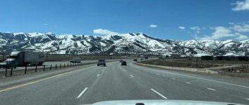
The old and scenic mountain road was amazingly uncrowded, as noted on this brief pit stop.
Though in good shape it was twisty and even with no traffic you could only drive about 25mph.
The old road passed by the Las Rusias radio tower reachable by a short but unpaved and rocky access driveway to 9,400 feet. The top was still forested but the attendants were hospitable and offered to let us climb it!
But there were clouds to the west and north while east was clear so we moved on and gave eclipse glasses to the attendants. And Liz gave this guy a pep talk about totality!
We finally reached the exit we wanted going north to Otinapa or south to El Soldado. We turned south as there were clouds far north but stopped when we saw a van with some people from Britain and Australia and a camera setup about 45 minutes before second contact. Soon we were joined by a lone German.
Overall these rural roads were startlingly empty of eclipse chasers. 100% of the traffic issues were due to that horrific accident. The Brits had seen it the afternoon before. Two big rigs collided and one of them burst into flames.
We had the clear skies at 8,000 feet we had put in the effort to find. Weather models don’t do clouds well, but any clouds approaching from the west (it was somewhat windy) broke apart before they reached our longitude. There were lightly scattered clouds to the east past Durango, but all reports we read later from Durango and Torreon were also successful, though one from Torreon mentioned cirrus like Mazatlan.
We got a new camera Canon EOS R50 with a not cheap 100-400 zoom lens, but had little time to practice with it. I set it up leeward of our car and lined up the Sun with a homemade solar filter during the partial phase.
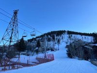
A couple of ambient views in the minutes before totality:
With no filter the Sun dazzles even as a sliver, but you can see the sky is noticeably darker to the right (west) in direction of approaching shadow.
One of the Brits recorded our coordinates:
This spot had 4 minutes 13 seconds of totality. Centerline to the north was as much as 4:27, but we wanted to steer clear of any clouds moving from that direction.
After I fell asleep Sunday night, Liz to her great credit studied the camera more and took some shots during totality. These are long exposures showing more outer corona that was probably not seen through cirrus at Mazatlan:
With wind a lot of the long exposure pics were blurred, but Liz took a bunch and the above two were the best. We are near solar sunspot maximum now, and the corona is more round shaped then.
Short exposures display prominences the best.
The one at 4 o’clock was visible right after second contact despite being the opposite side, and by that second picture late in totality had a loop visible through my binoculars.
Third contact diamond ring, a little late:
There’s a little bit of chromosphere visible on either side.
Numerous observers have commented upon that dazzling third contact Diamond ring, probably due to an unusually deep but narrow valley on the Moon. This was a darker than average eclipse with Venus and Jupiter very bright. This was less noted in the Northeast where the path was narrower and some optimal viewing spots like Sugarloaf (2:21 totality) were farther off centerline. Patrick was also on top of Sugarloaf but never met Powderchaser Steve.
The toll road was still closed going back with no warning signs or smartphone notifications. Debris where we turned around:
So we drove back over the 25mph mountain road with a stop at this scenic overlook.
There are canyon views both north:
And south:
Note that it’s much cloudier in the mountains now than before the eclipse.
Most settlements on the mountain road were about this size:
Back on the toll road, it was still jammed with trucks waiting to go to Durango.
There were a few of these Mexican army convoys too.
We got back to our Mazatlan hotel 5pm, more than 11 hours after we left. I took a dip in the ocean and a soak in the Jacuzzi. Mazatlan had a cloudy but colorful sunset.
Today there is not a cloud in the sky.


")