The Wasatch Crest is one of Utah's premiere mountain biking trails, and runs along the Park City ridgeline from Guardsman Pass near Brighton to the head of Mill Creek Canyon, above Canyons Resort. Most folks shuttle from the mouth of Mill Creek Canyon year my house to the top of Guardsman Pass, then ride it northbound, followed by a nearly 5,000 vertical-foot descent back to Wasatch Boulevard where they parked, although some animals that I know will do it in reverse. Even when taking it the sane way it still has a total elevation gain of 2,277 feet and a total loss of 6,933 feet.
I've hiked portions of it and have long wanted to ride the whole thing, but until this fall I wasn't sure that I was in adequate biking shape for it. After riding a bunch over the past month or so, however, I decided to finally give it a shot yesterday along with AmyZ. And with the long-range weather forecast this weekend may well have been our last chance to ride it this season.


Gee, it's been a while! Stylin'... :roll:
It's possible to catch a commercial shuttle from Mill Creek to the top of Guardsman Pass for a very reasonable $12 per person but that shuttle service ended for the season last weekend. They're only provided on even days as the trails in upper Mill Creek Canyon are open to mountain biking only on even-numbered days. Odd numbered days are off-leash dog days in Mill Creek. So Mrs. Admin graciously offered to drive us to the summit of Guardsman Pass to start the ride.

At the trailhead at Guardsman Pass (Wasatch denizens, note the new pavement!)
The photo above was taken during a brief moment when cars cleared out of the Guardsman lot. The trail was packed yesterday as many folks took advantage of the weather to get in one last ride on the Crest. That's not to say, however, that it was warm as temperatures topped out with afternoon highs barely above 40ºF at elevation.
The single track route actually drops off of Guardsman pass via some switchbacks to Scotts Pass via the Scotts Bypass Trail. Just before reaching the pass the trail crosses a steep sidehill through tight trees where some rocks and roots will give one pause. There were a couple of moments that featured the same butterflies in the stomach for me that I still occasionally experience while skiing when about to drop into some steep chute. I was therefore rather relieved to arrive at the pass, which sits at the head of Park City Mountain Resort's Thaynes Canyon. This will be familiar to skiers as the bowl you drop into from the top of the Jupiter Chair that includes Portugese Gap and the hike to Pinecone Ridge.

Thaynes Canyon at Park City Mountain Resort

The start of the Pinecone Ridge bootpack at Park City Mountain Resort

Two riders coming up from Park City with PCMR's Jupiter Bowl and Jupiter Hill in the background
Scotts Pass, unfortunately, is also the start of the aptly-named Puke Hill, a half-mile stretch of dirt road that leads up to the transmission stations on Scott Hill that are clearly visible across Big Cottonwood Canyon to those skiing at Solitude. There were two places yesterday that were hike-a-bike for me, and I knew in advance that Puke Hill would be one of them.

The start of Puke Hill

Looking across Big Cottonwood Canyon at Solitude Mountain Resort

And here's why it's called Puke Hill

The final push up Puke Hill -- that's the top of PCMR's Jupiter lift in the center middleground and the peak furthest to the right is Great Western at Brighton
About half the riders walked it while the 50% who are more fit and aggro grunted up Puke Hill in the saddle. AmyZ and I were in the former 50%, although to her credit she actually rode a couple of small portions of it. We paused to rest at the top, as did virtually everyone else. From there it's a short stretch of dirt road to the Scott Hill transmission sites before the single track resumes.

The transmission towers on Scott Peak

Brighton

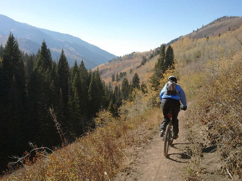
AmyZ on the Wasatch Crest Trail as the single track resumes. That's Solitude at left.
The stretch between PCMR and Canyons Resort features a lot of up and down along the Park City ridgeline. I took an honest shot at riding the grade up to the the top of the peak just south of Ninety-Nine 90, but halfway up I faced reality and started walking for my second and last hike of the day.

Solitude Mountain Resort

Climbing up to Ninety-Nine 90

Admin near the top of Ninety-Nine 90 at Canyons Resort. This is the first (and quite probably and hopefully the last) time you'll ever see a photo of me in tights. :lol:

Admin looking across Dutch Draw to the top of Ninety-Nine 90 at Canyons Resort
Shortly thereafter riders reach what's known as The Spine, a horribly uneven 75-yard stretch of solid rock that threatens to grab your tire and throw you over the edge. Most walk it. I tried to ride it, but halfway through got the bejeezuz scared out of me. This picture simply doesn't do it justice as the hairy spots are too far from the camera position.

Marc tries (unsuccessfully) to ride The Spine

Lake Desolation, where we camped back in 2008
One more long uphill grunt led us to the divide between Big Cottonwood and Mill Creek Canyons.

Amy Zaref at the divide between Big Cottonwood and Mill Creek Canyons
This is really the last substantial climb. From here the trail continues to follow the crest as it wraps around the head of Mill Creek Canyon from south to north before descending into the canyon at its northeast end.

Upper Mill Creek Canyon

Looking down on the lifts of Canyons Resort
That's not to say, however, that it's without it's more technical sections.

I still can't believe I actually made it down this in one piece

AmyZ on the Wasatch Crest Trail

The top of Super Condor from the Wasatch Crest Trail
My thermometer read 42 degrees as we reached the top of the descent into Mill Creek and we stopped to each add layers of clothing for the high-speed run to the Big Water parking lot.

Ice still unmelted at 4pm from the night before!
Halfway down one has two options from which to choose: stick to the traditional route along the Great Western Trail, or split off across a bridge onto the new Red Pine Road Trail for a straighter, steeper, faster descent. We took the latter.
AmyZ descends Red Pine Road trail in Mill Creek Canyon
We were at the Big Water parking area at the dead end of the Mill Creek Canyon Road before we knew it. From here the only decent option, at least for a few miles, is on pavement and at 30+ mph the 42-degree air was a might bit nippy. At Elbow Fork, however, you get another choice: stick to the road, or branch off onto the Pipeline Trail. Once again we chose the latter, and at this elevation the fall foliage was absolutely gorgeous to ride through.

Amy Zaref rides Pipeline trail in Mill Creek Canyon
Pipeline trail in Mill Creek Canyon
There are several ways to descend from Pipeline back to the road, and we chose the last one, Rattlesnake Gulch, which deposits you on the road just above the fee booth and about a mile from the Salt Lake neighborhoods.

At the top of the last descent, down Rattlesnake Gulch from Pipeline
It wasn't much longer before we rode into my driveway, 24.51 miles after leaving Guardsman Pass.
Those interested in trying the Wasatch Crest may find a full trail guide, more photos and a video at http://www.utahmountainbiking.com/trails/wasatch.htm.
I've hiked portions of it and have long wanted to ride the whole thing, but until this fall I wasn't sure that I was in adequate biking shape for it. After riding a bunch over the past month or so, however, I decided to finally give it a shot yesterday along with AmyZ. And with the long-range weather forecast this weekend may well have been our last chance to ride it this season.
Gee, it's been a while! Stylin'... :roll:
It's possible to catch a commercial shuttle from Mill Creek to the top of Guardsman Pass for a very reasonable $12 per person but that shuttle service ended for the season last weekend. They're only provided on even days as the trails in upper Mill Creek Canyon are open to mountain biking only on even-numbered days. Odd numbered days are off-leash dog days in Mill Creek. So Mrs. Admin graciously offered to drive us to the summit of Guardsman Pass to start the ride.
At the trailhead at Guardsman Pass (Wasatch denizens, note the new pavement!)
The photo above was taken during a brief moment when cars cleared out of the Guardsman lot. The trail was packed yesterday as many folks took advantage of the weather to get in one last ride on the Crest. That's not to say, however, that it was warm as temperatures topped out with afternoon highs barely above 40ºF at elevation.
The single track route actually drops off of Guardsman pass via some switchbacks to Scotts Pass via the Scotts Bypass Trail. Just before reaching the pass the trail crosses a steep sidehill through tight trees where some rocks and roots will give one pause. There were a couple of moments that featured the same butterflies in the stomach for me that I still occasionally experience while skiing when about to drop into some steep chute. I was therefore rather relieved to arrive at the pass, which sits at the head of Park City Mountain Resort's Thaynes Canyon. This will be familiar to skiers as the bowl you drop into from the top of the Jupiter Chair that includes Portugese Gap and the hike to Pinecone Ridge.
Thaynes Canyon at Park City Mountain Resort
The start of the Pinecone Ridge bootpack at Park City Mountain Resort
Two riders coming up from Park City with PCMR's Jupiter Bowl and Jupiter Hill in the background
Scotts Pass, unfortunately, is also the start of the aptly-named Puke Hill, a half-mile stretch of dirt road that leads up to the transmission stations on Scott Hill that are clearly visible across Big Cottonwood Canyon to those skiing at Solitude. There were two places yesterday that were hike-a-bike for me, and I knew in advance that Puke Hill would be one of them.
The start of Puke Hill
Looking across Big Cottonwood Canyon at Solitude Mountain Resort
And here's why it's called Puke Hill
The final push up Puke Hill -- that's the top of PCMR's Jupiter lift in the center middleground and the peak furthest to the right is Great Western at Brighton
About half the riders walked it while the 50% who are more fit and aggro grunted up Puke Hill in the saddle. AmyZ and I were in the former 50%, although to her credit she actually rode a couple of small portions of it. We paused to rest at the top, as did virtually everyone else. From there it's a short stretch of dirt road to the Scott Hill transmission sites before the single track resumes.
The transmission towers on Scott Peak
Brighton
AmyZ on the Wasatch Crest Trail as the single track resumes. That's Solitude at left.
The stretch between PCMR and Canyons Resort features a lot of up and down along the Park City ridgeline. I took an honest shot at riding the grade up to the the top of the peak just south of Ninety-Nine 90, but halfway up I faced reality and started walking for my second and last hike of the day.
Solitude Mountain Resort
Climbing up to Ninety-Nine 90
Admin near the top of Ninety-Nine 90 at Canyons Resort. This is the first (and quite probably and hopefully the last) time you'll ever see a photo of me in tights. :lol:
Admin looking across Dutch Draw to the top of Ninety-Nine 90 at Canyons Resort
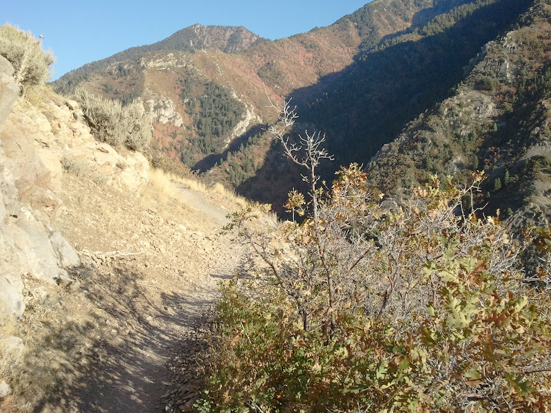
Shortly thereafter riders reach what's known as The Spine, a horribly uneven 75-yard stretch of solid rock that threatens to grab your tire and throw you over the edge. Most walk it. I tried to ride it, but halfway through got the bejeezuz scared out of me. This picture simply doesn't do it justice as the hairy spots are too far from the camera position.
Marc tries (unsuccessfully) to ride The Spine
Lake Desolation, where we camped back in 2008
One more long uphill grunt led us to the divide between Big Cottonwood and Mill Creek Canyons.
Amy Zaref at the divide between Big Cottonwood and Mill Creek Canyons
This is really the last substantial climb. From here the trail continues to follow the crest as it wraps around the head of Mill Creek Canyon from south to north before descending into the canyon at its northeast end.
Upper Mill Creek Canyon
Looking down on the lifts of Canyons Resort
That's not to say, however, that it's without it's more technical sections.
I still can't believe I actually made it down this in one piece
AmyZ on the Wasatch Crest Trail
The top of Super Condor from the Wasatch Crest Trail
My thermometer read 42 degrees as we reached the top of the descent into Mill Creek and we stopped to each add layers of clothing for the high-speed run to the Big Water parking lot.
Ice still unmelted at 4pm from the night before!
Halfway down one has two options from which to choose: stick to the traditional route along the Great Western Trail, or split off across a bridge onto the new Red Pine Road Trail for a straighter, steeper, faster descent. We took the latter.
AmyZ descends Red Pine Road trail in Mill Creek Canyon
We were at the Big Water parking area at the dead end of the Mill Creek Canyon Road before we knew it. From here the only decent option, at least for a few miles, is on pavement and at 30+ mph the 42-degree air was a might bit nippy. At Elbow Fork, however, you get another choice: stick to the road, or branch off onto the Pipeline Trail. Once again we chose the latter, and at this elevation the fall foliage was absolutely gorgeous to ride through.
Amy Zaref rides Pipeline trail in Mill Creek Canyon
Pipeline trail in Mill Creek Canyon
There are several ways to descend from Pipeline back to the road, and we chose the last one, Rattlesnake Gulch, which deposits you on the road just above the fee booth and about a mile from the Salt Lake neighborhoods.
At the top of the last descent, down Rattlesnake Gulch from Pipeline
It wasn't much longer before we rode into my driveway, 24.51 miles after leaving Guardsman Pass.
Those interested in trying the Wasatch Crest may find a full trail guide, more photos and a video at http://www.utahmountainbiking.com/trails/wasatch.htm.
")