Belatedly I’m posting the report Fraser was requesting of the clear day in the Jungfrau. As expected going through the pics was time consuming.

Liz and I spent three nights at the half board Alpenrose Hotel in Wengen. Since our first day Saturday was the only one with a clear weather forecast we prioritized the Jungfraujoch viewpoint at 11,300 feet. The train rides and activities consumed 3 hours so we only skied 12,200 vertical. The weather and being Saturday made it very busy. We were the only people wearing ski boots, as there were tons of Asian tourists who were spending 200CHF to go up there. It was 63CHF extra for us with a 3 or more day lift ticket.
From Wengen we started up this tram to Mannlichen.

You are not skiing back down this way, and the only way up the Lauberhorn side which you can ski down is by train.
Almost immediately we rounded up someone to take our picture with the Eiger in background.

We first skied under the Grindelwald-Mannlichen gondola. On a busy Saturday morning the line at its mid-station took 15 minutes.
Back up at Mannlichen, here’s the view down to Grindelwald, the largest lodging base:

The shaded gully behind Liz still had some powder from the Wednesday/Thursday storm. I skied in it on the way to the Lager chair.
The Grindelwald/First ski sector is not directly across from the Mannlichen terrain as depicted on the trail map. It is on the far side of the ridge to the left of Grindelwald. That means it’s south facing as well as relatively low altitude so we were not tempted to go over there.
From Lager we skied to Gummi and then to Eigernorwand. We did not take laps on any of these lifts as it was close to noon and our priority was to get up to the Jungfraujoch. We took some of those ski laps Monday.
As Liz exits the Eigernorwand lift, the Eiger is in profile behind her.

It looks like an average 70 degree slope over its 5,000+ vertical feet. The Matterhorn was first climbed in 1865 but the North Face of the Eiger was not climbed until 1938.
About 12:15 we reached the Eigergletscher building where we board the train up to the 11,362 foot Jungfraujoch.

The train was built into the rock between 1896 and 1912.
There is a 5 minute stop for this view out a window used for excavation during construction.


Train at the window stop:

There is an observation deck on the east side of the Jungfraujoch. On the south side is the head of the Aletsch Glacier.


Aletsch is 31.5 square miles in area and 14 miles long, similar dimensions as the Tasman Glacier in New Zealand which I skied by plane in 1982.
Close view of the Monch:

North side glacier, short as it falls off the precipitous cliffs:

View east to the Jungfrau, peak at center with caked snow on its right flank:

There are extensive inside exhibits at the Jungfraujoch.


The above tunnel has pictures of the train construction workers. Perhaps this is where Snowbird got the idea for the Peruvian tunnel décor.
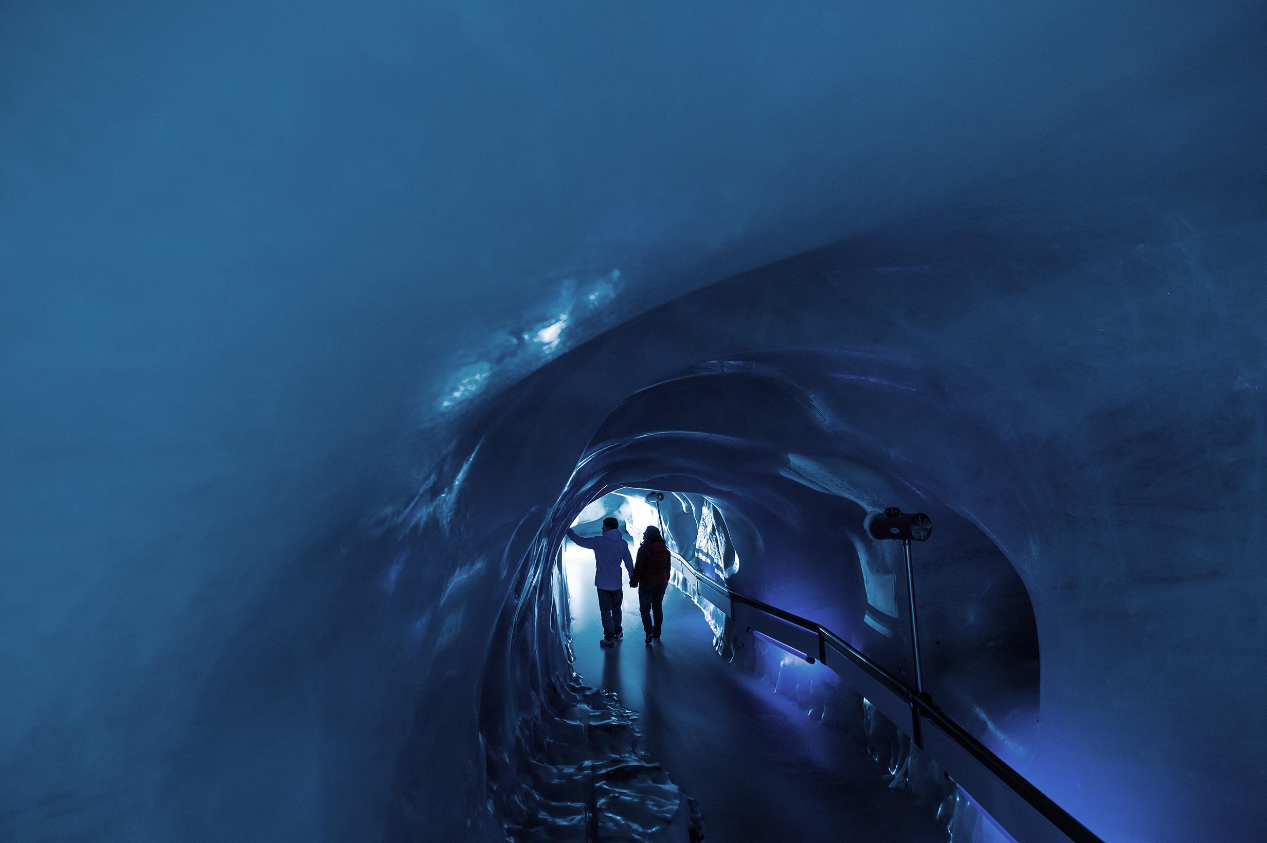
Next we descended into an ice tunnel.

Now we know why we were the only people up there in ski boots.

Ice sculptures:


We walked out the west side of the building to another viewpoint on the snow. Views from there:


There is a private elevator up to Europe’s highest observatory.
We rode the train back down to the Eigergletscher station, arriving about 3:15. View to Klein Scheidegg train station and Eiger:

We started down piste #32.


We reached the Wixi chair.

View up to Jungfraujoch and north side glacier falling off the cliff:

Eiger and Monch in late afternoon sun:

With the nice weather and being Saturday, lifts and pistes were very busy. So on the way to the Lauberhorn lift it was an easy call to bail off a catwalk onto this shaded slope.

It was now after 4pm so time to head down toward Wengen with the Jungfrau in direct view.

We skied on the blue 36 and 37 pistes as we suspected lots of scraped snow on the steeper Lauberhorn downhill at then end of a busy Saturday. But we had the Lauberhorn nearly to ourselves midday Monday with excellent conditions.
Liz and I spent three nights at the half board Alpenrose Hotel in Wengen. Since our first day Saturday was the only one with a clear weather forecast we prioritized the Jungfraujoch viewpoint at 11,300 feet. The train rides and activities consumed 3 hours so we only skied 12,200 vertical. The weather and being Saturday made it very busy. We were the only people wearing ski boots, as there were tons of Asian tourists who were spending 200CHF to go up there. It was 63CHF extra for us with a 3 or more day lift ticket.
From Wengen we started up this tram to Mannlichen.
You are not skiing back down this way, and the only way up the Lauberhorn side which you can ski down is by train.
Almost immediately we rounded up someone to take our picture with the Eiger in background.
We first skied under the Grindelwald-Mannlichen gondola. On a busy Saturday morning the line at its mid-station took 15 minutes.
Back up at Mannlichen, here’s the view down to Grindelwald, the largest lodging base:
The shaded gully behind Liz still had some powder from the Wednesday/Thursday storm. I skied in it on the way to the Lager chair.
The Grindelwald/First ski sector is not directly across from the Mannlichen terrain as depicted on the trail map. It is on the far side of the ridge to the left of Grindelwald. That means it’s south facing as well as relatively low altitude so we were not tempted to go over there.
From Lager we skied to Gummi and then to Eigernorwand. We did not take laps on any of these lifts as it was close to noon and our priority was to get up to the Jungfraujoch. We took some of those ski laps Monday.
As Liz exits the Eigernorwand lift, the Eiger is in profile behind her.
It looks like an average 70 degree slope over its 5,000+ vertical feet. The Matterhorn was first climbed in 1865 but the North Face of the Eiger was not climbed until 1938.
About 12:15 we reached the Eigergletscher building where we board the train up to the 11,362 foot Jungfraujoch.
The train was built into the rock between 1896 and 1912.
There is a 5 minute stop for this view out a window used for excavation during construction.
Train at the window stop:
There is an observation deck on the east side of the Jungfraujoch. On the south side is the head of the Aletsch Glacier.
Aletsch is 31.5 square miles in area and 14 miles long, similar dimensions as the Tasman Glacier in New Zealand which I skied by plane in 1982.
Close view of the Monch:
North side glacier, short as it falls off the precipitous cliffs:
View east to the Jungfrau, peak at center with caked snow on its right flank:
There are extensive inside exhibits at the Jungfraujoch.
The above tunnel has pictures of the train construction workers. Perhaps this is where Snowbird got the idea for the Peruvian tunnel décor.
Next we descended into an ice tunnel.
Now we know why we were the only people up there in ski boots.
Ice sculptures:
We walked out the west side of the building to another viewpoint on the snow. Views from there:
There is a private elevator up to Europe’s highest observatory.
We rode the train back down to the Eigergletscher station, arriving about 3:15. View to Klein Scheidegg train station and Eiger:
We started down piste #32.
We reached the Wixi chair.
View up to Jungfraujoch and north side glacier falling off the cliff:
Eiger and Monch in late afternoon sun:
With the nice weather and being Saturday, lifts and pistes were very busy. So on the way to the Lauberhorn lift it was an easy call to bail off a catwalk onto this shaded slope.
It was now after 4pm so time to head down toward Wengen with the Jungfrau in direct view.
We skied on the blue 36 and 37 pistes as we suspected lots of scraped snow on the steeper Lauberhorn downhill at then end of a busy Saturday. But we had the Lauberhorn nearly to ourselves midday Monday with excellent conditions.
Last edited:
 the point about how sprawling these ski regions are -- and as noted, the three separate sectors aren't interconnected by lifts -- but that's 14 miles across: