Alta, UT 3/29/08

Admin

Administrator
Staff member
Day 47: Repeat of Friday

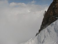
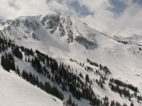
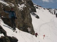
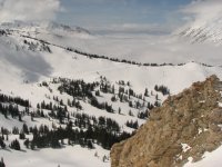
Another couple of inches atop the crust made for a repeat of Friday's conditions. Skidog, Marc_C, Tele Jon, Amy, Tirolerpeter, Dale and I all skied together until lunch, then I took a fe more runs with Marc_C, Amy and Tirolerpeter before throwing in the towel at 1:45.

The same suspects that produced good snow yesterday did the same today, with the highlights again North Rustler and Gunsight. With the locals staying home and tourist visits winding down, things were delightfully uncrowded today.

Lucky are those who will have Monday off, although tomorrow may not be bad, either:

The National Weather Service":3tvoo284 said:
Statement as of 2:56 PM MDT on March 29, 2008


... Heavy Snow Warning in effect from 10 PM this evening to 10 am
MDT Monday...

The National Weather Service in Salt Lake City has issued a Heavy
Snow Warning... which is in effect from 10 PM this evening to
10 am MDT Monday. The Winter Storm Watch is no longer in effect.

This warning is for the Salt Lake and Tooele valleys... the
southern Wasatch front and the Sanpete Valley. This includes Salt
Lake City... Provo and Manti.

Snow totals of 5 to 10 inches are expected by Monday morning. The
greatest totals will be in the Utah and Sanpete valleys and along
the benches in the Salt Lake and Tooele valleys.

Snow will develop in these areas tonight and will continue Sunday.
The snow could occasionally mix with or change over to rain in the
lowest portions of these valleys Sunday. A cold front with much
colder air is expected to cross the area Sunday night and this
will drop snow levels to all valley floors with accumulating snow
on valley roads.

A Heavy Snow Warning means significant amounts of snow are
forecast. Travel Sunday through early Monday may be hazardous
across the warning area. The snow Sunday night could
significantly impact the commute along the Wasatch front Monday
morning.

Cottonwood Canyons Forecast
This forecast is for use in snow safety activities and emergency management. Issued at: 2008-03-29 14:44:00

Synopsis:
A Heavy Snow Warning is in effect from tonight through Monday morning. Another Pacific trough will move into the area Sunday morning, bringing another round of snow to the mountains, with snow levels likely around 5500 feet AGL. A colder system with a well-defined cold front will move into the area Monday morning, which will drop snow levels down the valley floors. The precipitation on Sunday will favor areas that do well in southwest flow, while Monday's precipitation will be with a good northwest flow. Snow showers will continue in the mountains through the day Monday, and will be heavy at times.

1st Period: 12 Hour Forecast beginning 5:00 PM
Weather: Snow developing in the early morning Sunday.

Alta Guard Temp: 16 to 18

Snow


Amount Probability
Most Likely
1-3" 70%

Next Most Likely
4-5" 30%

Wind (MPH)


12 Hr Average Direction Gust

9000' Ridgelines
10-20
NW
25

11000' Ridgelines
20-30
W
30

Comment: winds becoming lighter and turning to the south in the early morning
Chance of Lightning: 0 %

2nd Period: 12 Hour Forecast beginning 5:00 AM
Weather: Snow throughout much of the day.

Alta Guard Temp: 26 to 28

Snow


Amount Probability
Most Likely
3-6 " 70 %

Next Most Likely
7-9 " 30 %

Wind (MPH)


12 Hr Average Direction Gust

9000' Ridgelines
15-25
SW
30

11000' Ridgelines
20-30
WSW
35

Comment: wind becoming more westerly through the day
 

Attachments

  • 04 alta gunsight 080329.jpg
    04 alta gunsight 080329.jpg
    44.7 KB · Views: 2,881
  • 03 alta baldy 080329.jpg
    03 alta baldy 080329.jpg
    97.5 KB · Views: 2,877
  • 02 alta gunsight hike marc_c tirolerpeter amy 080329.jpg
    02 alta gunsight hike marc_c tirolerpeter amy 080329.jpg
    95.6 KB · Views: 2,876
  • 01 alta undercast 080329.jpg
    01 alta undercast 080329.jpg
    101.9 KB · Views: 2,868
I hit the same areas with similar results. It was a pretty fun day. Figures that Monday will be good, I leave tomorrow. I would stay but a 5pm appointment in orange county makes that impossible. And sorry to tell you guys but I'll be back next weekend which means no new snow. 5 days at alta and still no powder days. Some luck.
 
ya just never know. in 2001 i had a buddy come out for 3 weeks from late feb through mid march and it did not snow a bit in the upper cottonwoods while he was there. we skied untracked pow every day in the b.c. however cuz the temps were on the cool side and the backcountry was quiet cuz people were getting the high pressure blues but, didn't realize how much new snow in recrystalization was forming at night. then two weeks later, another buddy of mine comes out from april 2-11 and it snowed everyday totalling 75 inches during his visit and we resort skied (solitude) every day cuz resort skiing was actually worth it with all of the new snow and at that time of year and in those days solitude was truly country club.
april could be great! have fun monday.
out here we're lookin at below normal temps maybe through april 20th after we get through the hot/wet spell early this week.
rog
 
You should come here in the winter if you're looking for powder days.
Alta averages 92 inches in March and 73 in April. The 6 inch days will be better in winter as they will be dust on crust in some aspects after a melt/freeze. But the big days of 18+ are nearly as frequent and just as good.

5 days at alta and still no powder days. Some luck.
I have 84 days lifetime at Alta/Snowbird: 3 days with 10K vertical or more powder, 6 days with 5-9K, 19 days with 1-4K. That leaves 56 days, or exactly 2/3 with no powder at all. And few on FTO would describe the 19 as "powder days." I'm sure this track record is below average even for the vacationing AltaBird skier, but the sample size is now 22 seasons and the point is still relevant. You need very good luck to get big powder days on advance planned trips to lift served areas. My good luck was earlier this season at Whistler and Castle Mt.

I will have to cite this as an example of admin's overly stubborn loyalty to Alta. You can nitpick about one day, but with 2 days of the same conditions, why wasn't one of them at Snowbird?
 
Tony Crocker":aog4xt8s said:
You should come here in the winter if you're looking for powder days.
Alta averages 92 inches in March and 73 in April. The 6 inch days will be better in winter as they will be dust on crust in some aspects after a melt/freeze. But the big days of 18+ are nearly as frequent and just as good.
However at this time of year the powder can go to wallpaper paste in a big hurry once the sun comes out, so the window for actual powder is even smaller, hence my suggestion to come in the winter.
 
3 days at Alta was due toy friend needing to be there with some work people paying for the rest of his stay till Wed. I liked Snowbird but the others were staying at the Rustler and wanted to stay on the alta side, plus they bought my lift ticket. Also, I was enjoying all the new terain I was able to find on this trip (high rustler, north rustler, east greely from the top, eagles nest. Catherines area, etc; i know its sad it took 3 days to find this stuff).

It was. A fun trip and thesnow out in catherines area was great today. I did two winter trips last year, but this year I did my long trip to jackson hole (5ft of snow in 6 days) plus an early whister/baker trip, tahoe, 2x at mammoth, and 3 ft powder day at baldy. Next weekend I'll. Be back for more next weekend, looking like some nice spring skiing . Already decided on a full week in slc next year, mid January.

Excuse the type-o's I'm on my iPhone sitting at the airport and don't type well on this.

Maybe I'll catch up with some of you next weekend. (flights delayed, hoping its cancelled)
 
My experience, and this is only 25 days total at Alta, is that about 1/3 of the days have been "true" powder days. When you think about it 1/3 of the time for powder during a series of 5 day vacations makes sense. On any given 5 day period, it could snow right before you come or right after you leave. If Alta averages 500 inches over a 6 month period (180 days) and we were to say the "average" storm drops 15 inches, then we get 1 storm for every 5.4 days... or roughly 1/3 of the season.
 
That extrapolation is a bit crude to do at the seasonal level, but I'm in process of trying to build a model at a monthly level. Both Jay Peak and Squaw Valley have posted several years of daily snowfalls online. If both area produce consistent results (ie a 100 inch month implies X% of 6+ inch days and Y% of 12+ inch days) I can probably apply that model to the whole database of monthly snow data.

I do recall that about 20% of Jay Peak days December- March have at least 6 inches new snow. So 1/3 is not an unreasonable guess for Alta.

Once you get a trip down to 5-7 days (as opposed to the monthly model) short-term persistence of weather is going to affect results. If the odds of powder one day are 1/3, the odds of no powder for 5 days would be (2/3)^5 = 13% if the 5 days are independent observations. But we know that clear weather, once it sets in, has some tendency to persist and thus the odds of no powder for 5 consecutive days are much higher than 13%.
 
Tony has mentioned before that I have a good batting average.

Alta powder days: 100% :wink:
Snowbird powder days: 100%

Okay, they only include 2 days each. :lol:
 
Tony Crocker":3lljt659 said:
Once you get a trip down to 5-7 days (as opposed to the monthly model) short-term persistence of weather is going to affect results(...)

That is why Lucky Luke left for 2 full weeks at Shames/Smithers. He knew that the odds of getting some serious snow would increase. As for myself, I got 5 days of dry and warm (relatively) weather. It started snowing for my last two days and continued for a few days after I left.
 
Tony has mentioned before that I have a good batting average.

Alta powder days: 100%
Snowbird powder days: 100%

Okay, they only include 2 days each.
Sounds like my batting average on 4 days at Castle Mt.: 92K vertical, 40K of powder.
 
Someone is looking for me?

<object width="425" height="355"><param name="movie" value="http://www.youtube.com/v/R6tiFMVRMB4&hl=en"></param><param name="wmode" value="transparent"></param><embed src="http://www.youtube.com/v/R6tiFMVRMB4&hl=en" type="application/x-shockwave-flash" wmode="transparent" width="425" height="355"></embed></object>
 
Tony Crocker":55z8jy90 said:
If both area produce consistent results (ie a 100 inch month implies X% of 6+ inch days and Y% of 12+ inch days) I can probably apply that model to the whole database of monthly snow data.

Once you get a trip down to 5-7 days (as opposed to the monthly model) short-term persistence of weather is going to affect results. If the odds of powder one day are 1/3, the odds of no powder for 5 days would be (2/3)^5 = 13% if the 5 days are independent observations. But we know that clear weather, once it sets in, has some tendency to persist and thus the odds of no powder for 5 consecutive days are much higher than 13%.

:-k
 
The example I use to illustrate volatility is this (written in 1995 but still applies):
Grand Targhee has a 21-season average of 464 inches and a low standard deviation of 71 inches. This means that snowfall for two-thirds of all ski seasons at Targhee will be between 393 and 535 inches. (Indeed, during this period there were only two seasons of over 600 inches and only two seasons under 300.) Contrast these figures to Kirkwood, where the 23-season average is a comparable 467 inches, but the standard deviation is a whopping 145 inches, the result of three seasons of over 700 inches, four additional seasons over 600, plus three seasons of under 200 and another four under 300--a much greater range of seasonal variation than found at Targhee.

On a daily basis this means that Targhee has a lot of 6 inch days, while Kirkwood has a lot of clear days and more 3+ foot dumps. The question which I have not answered yet is whether monthly data will explain most of this volatility. If so I can translate the voluminous monthly data into what many of you really want to know: what is the long range probability of 6+ inches new snow (riverc0il's benchmark) on a midwinter day?
 
Tony Crocker":1svky9xw said:
Once you get a trip down to 5-7 days (as opposed to the monthly model) short-term persistence of weather is going to affect results. If the odds of powder one day are 1/3, the odds of no powder for 5 days would be (2/3)^5 = 13% if the 5 days are independent observations. But we know that clear weather, once it sets in, has some tendency to persist and thus the odds of no powder for 5 consecutive days are much higher than 13%.

I wasn't trying to be too scientific. I know your game is numbers. However, my guess is that if you asked most people who have skied Alta 15 days or more, most of them would have experienced around 5 days (1/3 of the the time) or so of powder.
 
Back
Top