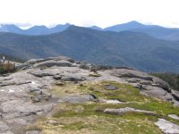
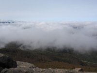
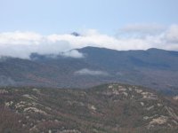
Back out in the ADK?S today, this time on Cascade Mtn (Elev. 4086 ft just east of the Lake Placid area). Dense fog settled in over the entire area this morning with a low cloud cover that dispersed by midday. Attached are some mountain pictures while we wait for the snow.
You are using an out of date browser. It may not display this or other websites correctly.
You should upgrade or use an alternative browser.
You should upgrade or use an alternative browser.
CASCADE MOUNTAIN NY ( ADK'S)
- Thread starter Anthony
- Start date

tirolerpeter
New member
The last picture has some "white" spots. Is that snow, or just the reflection of the sky?
jasoncapecod
Well-known member
No you can't ski there but, the Ice Climbing is awsome
jasoncapecod":s0wipek7 said:No you can't ski there but, the Ice Climbing is awsome
Did you forget to add a " :wink: " after that?? There's lots of skiing to be had on the slides in the 'Dacks.
tirolerpeter":10tm436z said:The last picture has some "white" spots. Is that snow, or just the reflection of the sky?
These white spots were not so obvious while walking around as they are in the pic. They are probably reflections off the different minerals in the rock. Hey, but keep thinking snow , it won't be long now before traces of snow show up at the 4000' level.
highpeaksdrifter
New member
Cascade is a nice hike. Great views for little effort. Did you go over and bag Porter too?
Wanted to go over to Porter as it is only 1.4 mile return from the junction but we got off to a late start that day because of the heavy fog which obscured the summits until noon and then had to be back in Quebec at a certain time . Will be heading over to Ampersand next. Hiking this time of year keeps the flame stoked for the approaching ski season.
nice pics
been lucky to get out quite a bit the last two weeks.
Hiked Santanoni range ~17 miles a couple weeks ago. It was a brutal day trip. Next time in I'd plan to stay one night near Bradley Pond or the Duck hole and then hike Santanoni. Couche and Panther the next day. Trail is muddy, steep and rooted!
Last Firday hiked the Sewards - Seward, Donaldson and Emmons. What a mud fest that was! Total distance for 3 Seward mountains = 9.5 miles with combined elevation change = 5490 feet
Then on Tuesday we did the Dix Range. Hiked along the South Fork and up the slide on East Dix. Great trail!!
Total distance for Dix Range Traverse = 15.5 miles with combined elevation change = 9750 feet (includes East and South Dix, Macomb back over South Dix, then Hough and Finally Dix)
Dix range offers some incredible views..
Wish I knew how to resize photos???