You are using an out of date browser. It may not display this or other websites correctly.
You should upgrade or use an alternative browser.
You should upgrade or use an alternative browser.
Eastern NoAm Weather 2008-09
- Thread starter Harvey
- Start date
Sharon":3rqtf2rf said:NOAA is saying New snow and sleet accumulation of 3 to 5 inches possible for Northern Warren Co.
That could be alotta ice...but if we get a storm on the weekend, that ice would be a bomber base.
Sharon...could you post a link for that? I've only got NWS links.
James that's a NWS link. Was looking for Sharon NOAA link.
This is from NWS KALB 4pm update:
ACROSS OUR ADIRONDACKS...SLEET COULD MIX IN WITH SNOW...BUT WE THINK SNOW WILL BE THE PREDOMINATE PTYPE...WITH AMOUNTS 7 TO 10 INCHES WITH A GOOD SHOT THROUGH THE EARLY MORNING HOURS...LIGHTENING UP (AND THIS IS WHEN IT MIGHT MIX WITH SLEET) MIDDAY WEDNESDAY...BEFOREANOTHER ROUND OF HEAVIER SNOW MOVES IN BY EVENING. ON TOP OF THAT...WILL LIKELY BE SOME LAKE EFFECT PRODUCED SNOW.

Sorry for being a weather dope, but both the NOAA and NWS logos are at the top of that link.
BTW, don't you have a family and responsibilities? 8-[
BTW, don't you have a family and responsibilities? 8-[
jasoncapecod
Well-known member
BTW, don't you have a family and responsibilities? 8-[
Just you and me :wink: :lol:
jamesdeluxe":3fxb5iwp said:Sorry for being a weather dope, but both the NOAA and NWS logos are at the top of that link.
BTW, don't you have a family and responsibilities? 8-[
I noticed that the NOAA logo is up there. I always assumed that was NWS because the forecast discussion has NWS in it. I guess they are related.
If it makes you feel any better it does look like I am hosed for this weekend and next with job stuff.
jasoncapecod
Well-known member

Harvey44":byqrlt1o said:If it makes you feel any better it does look like I am hosed for this weekend and next with job stuff.
Sheesh... next time I make a joke, I'll raise my hand first.
URGENT - WINTER WEATHER MESSAGE
NATIONAL WEATHER SERVICE ALBANY NY
1137 AM EST MON JAN 26 2009
...WINTER STORM WATCH IN EFFECT FROM LATE TUESDAY NIGHT THROUGH WEDNESDAY EVENING...
THE NATIONAL WEATHER SERVICE IN ALBANY HAS ISSUED A WINTER STORM WATCH...WHICH IS IN EFFECT FROM LATE TUESDAY NIGHT THROUGH WEDNESDAY EVENING FOR ALL OF EASTERN NEW YORK AND WESTERN NEW ENGLAND.
A STORM DEVELOPING OVER THE SOUTHWEST UNITED STATES IS EXPECTED TO TRACK NORTHEAST TOWARD THE REGION TUESDAY NIGHT. SNOW ASSOCIATED WITH THIS SYSTEM IS FORECAST TO SPREAD FROM SOUTHWEST TO NORTHEAST OVERNIGHT AND MAY BECOME HEAVY AT TIMES WEDNESDAY MORNING.
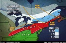
SNOWFALL AMOUNTS BY WEDNESDAY NIGHT COULD RANGE BETWEEN 6 AND 12 INCHES...WITH THE HIGHER TOTALS ACROSS THE HIGHER TERRAIN.
NATIONAL WEATHER SERVICE ALBANY NY
1137 AM EST MON JAN 26 2009
...WINTER STORM WATCH IN EFFECT FROM LATE TUESDAY NIGHT THROUGH WEDNESDAY EVENING...
THE NATIONAL WEATHER SERVICE IN ALBANY HAS ISSUED A WINTER STORM WATCH...WHICH IS IN EFFECT FROM LATE TUESDAY NIGHT THROUGH WEDNESDAY EVENING FOR ALL OF EASTERN NEW YORK AND WESTERN NEW ENGLAND.
A STORM DEVELOPING OVER THE SOUTHWEST UNITED STATES IS EXPECTED TO TRACK NORTHEAST TOWARD THE REGION TUESDAY NIGHT. SNOW ASSOCIATED WITH THIS SYSTEM IS FORECAST TO SPREAD FROM SOUTHWEST TO NORTHEAST OVERNIGHT AND MAY BECOME HEAVY AT TIMES WEDNESDAY MORNING.
SNOWFALL AMOUNTS BY WEDNESDAY NIGHT COULD RANGE BETWEEN 6 AND 12 INCHES...WITH THE HIGHER TOTALS ACROSS THE HIGHER TERRAIN.
yak
New member
I was planning on heading up to the Rivah tomorrow evening with a buddy who's never skied it before, but after looking at the forecast we're diverting to Kmart to see if we can take advantage of the earlier falling snow (since we're only skiing Wed). I hope the storm pushes further north than the forecast.
icelanticskier
New member
josh fox is calling for a conservative 10-20 inches for the mad river area for wed/thurs with maybe more. i'm bummed that my days off are wed/thurs \ /
/
rog
/ rog
jasoncapecod
Well-known member
icelanticskier
New member
ya, pretty much. :-$
rog
rog