DD Powder
New member
I understand that Powderfreak is the resident meteorologist around here so I don’t want to step on any feet, but as a professional meteorologist I need to call out Jay Peak's marketing on this one. I did not start this thread to provide a detailed forecast for tonight/tomorrow's upcoming event. Rather, to point out the inaccuracies of Jay's snow report which were clearly meant to mislead the general public.
From today’s Jay Peak snow report:
“It was mild again yesterday but we didn’t get the rain we were expecting. Temperature started dropping and once we hit the freezing mark, all groomers were on full force, tilling the surfaces. Surfaces will be variable with machine groomed, frozen granular and maybe a few bare spots on natural snow trails. Our forecast is calling for 2-4” tonight with colder temps and flurries/snow Friday night, Saturday and Saturday night."
This forecast is very misleading as they have conveniently missed the substantial mix/rain between the estimated 2-4” tonight and the flurries/snow Friday night through Saturday. The 2-4” is in the realm of possibilities however all models and forecast guidance are showing warm air at mid levels working into the area causing a changeover to more of a sleet/freezing rain situation for jay during the morning. Surface temperatures will likely be going above freezing by late Friday morning/afternoon changing remaining precipitation to all rain before the cold front passage.
I am not trying to stop people from skiing Jay tomorrow. As most people know around here any day on the mountain is better than just about anything else. I am just giving you a heads up on the weather conditions for Friday that they “somehow” left out. After tonight’s snow expect a mess of mixed precip with sleet going over to rain as the day progresses...end rant.
What are your thoughts Powderfreak?
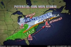
Finally...fingers crossed everyone for Mondays possible storm.
From today’s Jay Peak snow report:
“It was mild again yesterday but we didn’t get the rain we were expecting. Temperature started dropping and once we hit the freezing mark, all groomers were on full force, tilling the surfaces. Surfaces will be variable with machine groomed, frozen granular and maybe a few bare spots on natural snow trails. Our forecast is calling for 2-4” tonight with colder temps and flurries/snow Friday night, Saturday and Saturday night."
This forecast is very misleading as they have conveniently missed the substantial mix/rain between the estimated 2-4” tonight and the flurries/snow Friday night through Saturday. The 2-4” is in the realm of possibilities however all models and forecast guidance are showing warm air at mid levels working into the area causing a changeover to more of a sleet/freezing rain situation for jay during the morning. Surface temperatures will likely be going above freezing by late Friday morning/afternoon changing remaining precipitation to all rain before the cold front passage.
I am not trying to stop people from skiing Jay tomorrow. As most people know around here any day on the mountain is better than just about anything else. I am just giving you a heads up on the weather conditions for Friday that they “somehow” left out. After tonight’s snow expect a mess of mixed precip with sleet going over to rain as the day progresses...end rant.
What are your thoughts Powderfreak?
Finally...fingers crossed everyone for Mondays possible storm.

") ) that Jay does not actually do "forecasting" but merely reports on what the forecasters they trust are saying......
) that Jay does not actually do "forecasting" but merely reports on what the forecasters they trust are saying......